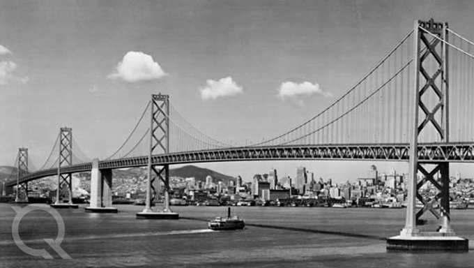
Are you interested in images from the golden age of flight, featuring groundbreaking aircraft and aviators like Amelia Earhart, Howard Hughes and Charles Lindbergh? Maybe you’re curious about how the landscape of the San Francisco Bay Area has evolved since the 1930s, with the construction of the Golden Gate and Bay Bridges? Or perhaps you’re looking for historical photos of geographic features or landmarks from Alaska to California or in locations along the Eastern Seaboard?
If so, Quantum Spatial’s historical archive may pique your curiosity. With nearly 6 million images, many dating back to the 1920s, we have a vast, rich collection of aerial imagery that documents milestones in aviation and architectural history, and offers a unique perspective into geographical changes during the last century.
Conserving History
The origins of our collection date back to 1922, with images taken by Clyde Sunderland, an iconic photographer who spent more than 40 years photographing the San Francisco Bay Area and Northern California from the air. His subjects included the Pan American Exposition on Treasure Island, the U.S. Navy’s 7th Fleet – including the U.S.S. Arizona, and the industrial revolution of the San Francisco Bay Area.
A former Naval Reserve Officer based at the Oakland Airport, Clyde was able to forge personal connections that enabled him to photograph many historical moments and iconic personalities, such as Amelia Earhart, Charles Lindbergh and Howard Hughes’ film crew. Among his projects were aerial marketing photography for Pan American airlines, featuring images of the company’s famous “Clipper” planes flying above San Francisco to Hawaii, Hong Kong and Saipan.
Clyde’s collection was later purchased by Hammond, Jensen, Wallen & Associates Inc. (HJW) under the Pacific Aerial Surveys name. Today that collection is estimated at 1.5 million images and considered to be one of the most complete and largest aerial photo collections of Northern California.
After a series of mergers – most recently the combination Photo Science, AeroMetric and Watershed Sciences to create Quantum Spatial – we’ve begun to leverage our collection more and expand the archive, which includes negatives of early images taken on film to the digital images Quantum Spatial is collecting across the country today.
Among the highlights of the full collection are:
- Alaska – Historical images span as far back as 1938, when Howard Hughes landed in Fairbanks on his record-setting world flight. Also included are annual images of the Anchorage Bowl beginning in 1958, and periodic photos of the Matanuska Valley, Kenai, Fairbanks, Juneau, Ketchikan and many smaller villages.
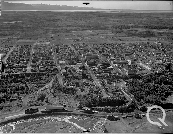
- Pacific Northwest – Starting as early as 1936, the collection includes several oblique images of Seattle, and frequent imaging of the Puget Sound and counties in Washington, Oregon, Idaho and Montana.
- Northern California – Biennial imagery collected of the area spanning from San Francisco, east to Sacramento and as far south as the San Joaquin Valley.
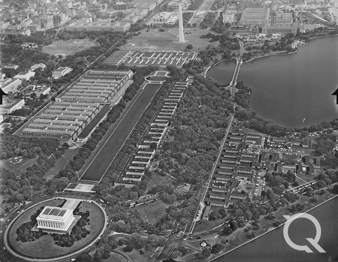
- Northeast – Annual photos were taken in black and white starting in 1959, and then color from 1988 to 2008, of the Washington, D.C., metropolitan area, including several counties in Northern Virginia. Other select areas of coverage include portions of Delaware, Pennsylvania, New Jersey, New York, Connecticut, Massachusetts, Rhode Island, Vermont and Maine.
Leveraging the Collection
There is more than just novelty and historical significance to the Quantum Spatial collection. This rich archive contains aerial imagery and remote sensing data that is valuable for a range of real-world applications – from real estate and legal services to mining, utility and environmental surveys.
From our archives images, we have a clear view of historic land use, environmental elements, geology, vegetation, wetlands, agriculture and urban growth. And we can combine our historic imagery with modern technologies – terrain modeling, LiDAR, GIS databases and GPS surveys – to show changes over time and assist with future planning.
The archives have proven particularly useful in civil and criminal litigation. As a former military imagery analyst and manager of this historical archive for more than 19 years, I’ve used our images and remote sensing data in a variety of legal cases involving property issues, such as boundary disputes, and other cases where lawyers needed to identify activities, equipment and geospatial relationships, or show changes over time.
I have worked on a variety of cases from civil to criminal and for homeowners, large corporations and the federal government.
Some interesting ones have included contamination from an alleged leaking tanker car owned by a railroad. One party produced a grainy, third party photo of what they thought was a tanker car. I was able to locate the original negative and produce high resolution prints showing that it was in fact a box car. Additional photos showed that the box car actually had the side door open. Historical aerials from the Quantum Spatial collection also showed the extensive use of the side tracks by various cars, none of which were tankers. The ability to show the historical use would be a deciding factor in the case.
On a personal injury case, a landscaper working along the shoreline, fell through a hole and drowned in an area that had previously been used for shipbuilding. Our historical imagery showed that vegetation gradually grew and covered an opening to a dry dock gate. The extensive coverage showed that the access hole had not been properly sealed like others in the area.
Quantum Spatial also uses current and historical imagery and remote sensing data to address natural disasters. One such event was the March 2014 Oso, Washington, mudslide, which destroyed 49 homes and killed 43 people. With data and images from 2013, a LiDAR survey done within hours after the slide and another similar survey a month later, Quantum Spatial was able to assist first responders, map excavation efforts and debris change.
If you are interested in learning more about the Quantum Spatial historical collection, or would like to access images, visit our archive page and fill out our Archive Inquiry form. Additionally, browse our newly launched Image Catalog, which will be continually updated. We look forward to being able to share these unique resources and assist with your geospatial needs.
Written by David Ruiz, Quantum Spatial Imagery Analyst / Data Archivist.