By Kurt Allen, Quantum Spatial Vice President Federal Vertical Lead
After witnessing firsthand the devastation landslides cause across a number of states, including Alaska, California and Washington, we believe the bipartisan, bicameral National Landslide Preparedness Act recently announced by Sen. Marie Cantwell (D-Wash.) and Sen. Lisa Murkowski (R-Alaska), ranking member and chairman, respectively, of the Senate Energy and Natural Resources Committee; Rep. Suzan DelBene (D-Wash.); Sen. Patty Murray (D-Wash.) and Sen. Diane Feinstein (D-Calif.), is a critical step forward in helping is a vital to ensuring that local communities are prepared for, and can respond to, landslides and other natural hazards.
In the news announcement regarding the legislation, Rep. DelBene summed up quite succinctly why this legislation is critical:
“In the wake of the Oso landslide, we learned many lessons, including that lawmakers need to do more to ensure we fund resources and research efforts to prevent future natural disasters from becoming national tragedies. Every state in the country faces some amount of landslide risk. Substantial work needs to be done to gain better knowledge of landslides and their potential impacts in order to reduce losses of life and property. It is time that landslide hazards are addressed properly and in a collaborative fashion. Our bill will boost significant scientific progress and help communities better prepare for when landslides do occur.”
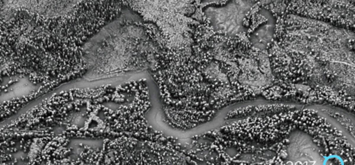
Washington State’s Oso landslide demonstrated firsthand the value that quick access to high-quality topographical data can bring in these disasters. Within 24 hours of the Oso landslide, Quantum Spatial captured LiDAR images of the massive debris field. Fortunately, six months before the landslide, we had collected LiDAR data in that same area on behalf of the Puget Sound LiDAR Consortium. Together, with the new LiDAR images collected immediately after the slide, our data provided critical information for first responders, revealing with stunning clarity the extent of the disaster. The Quantum Spatial data, including a survey done a few months after the landslide to evaluate the area for further changes, was then used by a wide variety of stakeholders and decision makers, including the Washington Department of Transportation, Snohomish County, the Federal Emergency Management Agency (FEMA) and U.S. Geological Survey (USGS) to plan for debris cleanup, as well as understand and identify future risk. Leading universities in the Northwest are also using the data to better understand slope stability and develop predictive methods to help prevent this type of tragedy in the future.
In addition, the Oso pre- and post-landslide LiDAR data we collected is being used by the 3D Elevation Program (3DEP) initiative developed by the USGS. Funded and promoted by USGS and an annual Broad Agency Announcement (BAA), the 3DEP program is a collaborative effort of local, state and federal agencies designed to systematically collect and make accessible high-quality, detailed topographical data nationwide. This enhanced LiDAR elevation data spanning the conterminous United States, Hawaii and the U.S. territories, can serve a variety of uses, from environmental preservation and infrastructure projects, to disaster management. Our work in connection with a number of landslides clearly demonstrates one especially strong use case for LiDAR data gathered as part of the 3DEP program, as it holds the promise of significantly improving conditions for people living in potential landslide areas.
But, our work doesn’t stop after we collect and analyze the LiDAR data. Quantum Spatial executives are working together with Congressional delegations to demonstrate the clear value of LiDAR for first responders, cleanup and recovery, and in the future for better prevention and mitigation. We fully support the 3DEP program and will be asking Congress to move forward with a procedure for national landslide detection.