Search
Archives

City of Folsom – Orangevale Avenue Bridge Rehabilitation

The Hanna Group was selected by the City of Folsom to provide Construction Management Services for the Orangevale Avenue Bridge Rehabilitation Project!

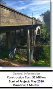
The Orangevale Avenue Bridge, constructed in 1915, crosses Gold Creek between Placer Mine Road and American River Parkway in the City of Folsom. In 1927 the bridge became a part of the Lincoln Highway, which at the time provided the best and fastest route between New York and San Francisco. From 1915 to 1948 the bridge provided the main connection between Folsom and Orangevale. During this time the bridge connected the citrus groves, orchards and produce gardens of Orangevale, Fair Oaks and Carmichael with the processing and shipping businesses in Folsom.

The open spandrel arch bridge is approximately 160 feet long and 20 feet wide with a 6” deck. Based on the age of the structure and a condition assessment prepared in 2007, it has been determined that removal and reconstruction of the eastern abutment and wingwalls along with the deck, beams, and spandrel columns are needed. The goal is to extend the bridge’s useful life and bring the load carrying capacity of the structure up to current standards, while protecting the historic appearance.

The major elements of this project include:

  • Temporary Sewer Relocation
  • Demolition of Deck and Spandrel Columns
  • Demolition of Abutment
  • Repair of Spalled Concrete on Arches and Remaining Abutment
  • Replacement of Columns, Deck and Abutment
  • Placement of Drainage Facilities
  • Placement of Permanent Sewer
  • Placement of Future Dry Utility Structure on Bridge

This project is a significant win for THG because we are establishing a relationship with a new client.

Fill out the form below to download the handbook.

Form #1 - Redirection to PDF

Form #2 - Sends email containing the link to the PDF

"*" indicates required fields

This field is for validation purposes and should be left unchanged.

eNewsletter - NV5 Real Estate Transaction Services

Contact NV5 Real Estate Transaction Services

Download NV5 2022 Compliance Calendar

Please fill out the form below. After successful form submission, you will be redirected to the requested file. Thank you.

"*" indicates required fields

This field is for validation purposes and should be left unchanged.
We are an equal opportunity employer. All applicants will be considered for employment without attention to race, color, religion, sex, sexual orientation, gender identity, national origin, veteran or disability status. We ensure nondiscrimination in all programs and activities in accordance with Title VI of the United States Civil Rights Act of 1964. If you need more information or special assistance for persons with disabilities or limited English proficiency, contact MaryJo OBrien at (954) 495-2112. Persons with hearing-and speech-impairments can contact the NV5 by using the Virginia Relay Service, a toll-free telecommunication device for the deaf (TDD). Call 711 for TTY/TDD.
This field is hidden when viewing the form

Hyperspectral Imaging - Technically Speaking

Our internal innovation and development team constantly analyzes new technology and develops solutions to meet our client’s challenges. Our Technically Speaking series is one way we share our technical findings with the professional community. 

Please tell us a little about yourself by filling out the form below, and we’ll share the document with you, thanks!

Accuracy Part 1- Technically Speaking

Our internal innovation and development team constantly analyzes new technology and develops solutions to meet our client’s challenges. Our Technically Speaking series is one way we share our technical findings with the professional community. 

Please tell us a little about yourself by filling out the form below, and we’ll share the document with you, thanks!

Prune Optimization Webinar Recording

NV5 Geospatial releases a new predictive modeling platform for vegetation management that uses existing lidar and historical data to identify the relative level of asset risk from trees by quantifying the potential for causing asset damage. 

Please tell us a little about yourself by filling out the form below, and we’ll share the document with you, thanks!

Topobathy Lidar - Technically Speaking

Our internal innovation and development team constantly analyzes new technology and develops solutions to meet our client’s challenges. Our Technically Speaking series is one way we share our technical findings with the professional community. 

Please tell us a little about yourself by filling out the form below, and we’ll share the document with you, thanks!

Contact Geospatial

Contact Geospatial