HOLLYWOOD, Fla., June 30, 2025 (GLOBE NEWSWIRE) — NV5, a provider of technology, certification, and consulting solutions, announced today that it has been awarded over $20 million in engineering design and construction management contracts by the New York City Department of Parks and Recreation to support parks and recreation facility[...]
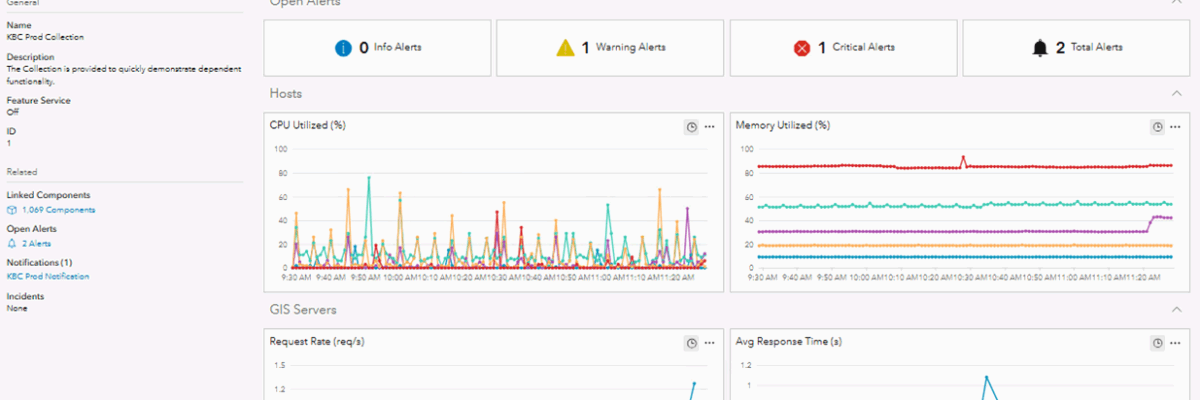
Challenge KBC Advisors, a fast-moving full-service real estate advisory firm, relies on ArcGIS Enterprise to deliver location-driven insights to its national network of brokers and clients. With workflows built around high-frequency parcel updates and web-based applications, GIS availability and performance are non-negotiable. Downtime or lag not only slows decision-making, it[...]
HOLLYWOOD, Fla., June 09, 2025 (GLOBE NEWSWIRE) — NV5, a provider of tech-enabled engineering, certification, and consulting solutions, announced today that it has been awarded $5 million to deliver engineering design services for multiple high-voltage substations supporting data center facilities in Georgia and Nevada. NV5 will deliver materials development specifications,[...]
HOLLYWOOD, Fla., June 05, 2025 (GLOBE NEWSWIRE) — NV5, a provider of tech-enabled engineering, certification, and consulting solutions, announced today that it has been selected by the National Oceanic and Atmospheric Administration (NOAA) for a five-year, multiple award contract valued at up to $250 million to provide shoreline mapping services[...]
Executive Summary When the world’s busiest airport needed to modernize its GIS and asset management capabilities, NV5 delivered. Through a multi-agency partnership with the City of Atlanta, NV5 implemented a modern solution grounded in Trimble Unity Powered by Cityworks and ArcGIS Enterprise, integrated real-time data automation, and transitioned infrastructure to[...]
HOLLYWOOD, Fla., May 28, 2025 (GLOBE NEWSWIRE) — NV5, a provider of tech-enabled engineering, certification, and consulting solutions, announced today that it has been awarded a two-year, $10 million statewide contract by the North Carolina Department of Transportation (NCDOT) to provide a comprehensive suite of geospatial and utility services to[...]
HOLLYWOOD, Fla., May 21, 2025 (GLOBE NEWSWIRE) — NV5, a provider of tech-enabled engineering, certification, and consulting solutions, announced today its strategic expansion into the South Korean data center market with the inclusion of SA Bricks, a leading specialist in commissioning and energy marshalling for data center infrastructure. NV5 has[...]
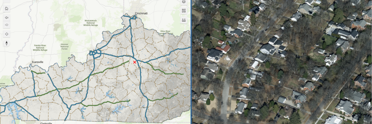
Empowering public access, flexibility, and cost savings through a modern viewing platform The Commonwealth of Kentucky has launched a groundbreaking new Nadir and Oblique Statewide Image Viewer as part of its KYFromAbove initiative—a statewide program providing high-resolution elevation data and aerial photography. This next-generation, publicly accessible viewer covers all 40,000+[...]
“Data is the new oil.” Nearly two decades ago, British mathematician Clive Humby made this statement, noting that both of these valuable resources needed to be “extracted, refined and processed to be truly useful.” For oil and gas companies, geospatial data is the new oil, and it’s growing in value.[...]
Form #2 - Sends email containing the link to the PDF
"*" indicates required fields
eNewsletter - NV5 Real Estate Transaction Services
Contact NV5 Real Estate Transaction Services
Download NV5 2022 Compliance Calendar
Please fill out the form below. After successful form submission, you will be redirected to the requested file. Thank you.
"*" indicates required fields
Hyperspectral Imaging - Technically Speaking
Our internal innovation and development team constantly analyzes new technology and develops solutions to meet our client’s challenges. Our Technically Speaking series is one way we share our technical findings with the professional community.
Please tell us a little about yourself by filling out the form below, and we’ll share the document with you, thanks!
Accuracy Part 1- Technically Speaking
Our internal innovation and development team constantly analyzes new technology and develops solutions to meet our client’s challenges. Our Technically Speaking series is one way we share our technical findings with the professional community.
Please tell us a little about yourself by filling out the form below, and we’ll share the document with you, thanks!
Prune Optimization Webinar Recording
NV5 Geospatial releases a new predictive modeling platform for vegetation management that uses existing lidar and historical data to identify the relative level of asset risk from trees by quantifying the potential for causing asset damage.
Please tell us a little about yourself by filling out the form below, and we’ll share the document with you, thanks!
Topobathy Lidar - Technically Speaking
Our internal innovation and development team constantly analyzes new technology and develops solutions to meet our client’s challenges. Our Technically Speaking series is one way we share our technical findings with the professional community.
Please tell us a little about yourself by filling out the form below, and we’ll share the document with you, thanks!