HOLLYWOOD, Fla., Feb. 07, 2018 (GLOBE NEWSWIRE) — NV5 Global, Inc.(Nasdaq:NVEE) (“NV5” or the “Company”), a provider of professional and technical engineering and consulting solutions, announced today that it has acquired CSA (M&E) Ltd., a leading provider of Mechanical, Electrical, and Plumbing (MEP) engineering and sustainability consulting services. With annual[...]
Establishing whether or not a property has access to a traveled roadway within a public roadway can be unclear and may create confusion for the surveyor and property owner. In this blog post, we will explain the responsibilities of the surveyor when surveying property near a public right-of-way. Minimum Standard[...]
Quantum Spatial, Inc.(QSI), the nation’s largest independent geospatial data firm, today announced that three of its LiDAR experts will be featured speakers at International LiDAR Mapping Forum (ILMF), which takes place February 5-7 in Denver. QSI also is exhibiting at the event, sharing its expertise in LiDAR data collection and[...]
San Diego, Calif. (January 2017) —Environmental Business Journal® (EBJ), a business research publication which provides high value strategic business intelligence to the environmental industry*, has honored 57 companies for revenue growth, acquisitions, innovative project designs, technology applications, new practice areas, social contributions and industry leadership in 2017. NV5 is pleased[...]
In commercial zoning, you will occasionally see the abbreviation PD or PUD. PD is the acronym for Planned Development, or Planned Unit Development. But what does this mean? In this blog post, we will discuss the meaning and uses of PUD. What is a Planned Unit Development? When a property[...]
HOLLYWOOD, Fla., Jan. 16, 2018 (GLOBE NEWSWIRE) — NV5 Global, Inc.(Nasdaq:NVEE) (“NV5” or the “Company”), a provider of professional and technical engineering and consulting solutions, announced today that it has acquired Butsko Utility Design, Inc.(“Butsko”), a leading provider of utility planning and design services. With annual revenues exceeding $5 million,[...]
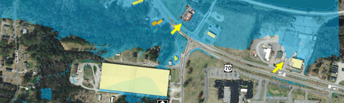
Michael Shillenn, of Quantum Spatial, details how North Carolina is managing flood risk through improved mapping and analysis of LiDAR data, made possible via the USGS’ 3D Elevation Program (3DEP). The article reveals the accuracy and precision of the flood analysis with real-life examples of floods that responded exactly as[...]
Hollywood, FL – December 28, 2017 – NV5 Global, Inc. (Nasdaq: NVEE) (“NV5” or the “Company”), a provider of professional and technical engineering and consulting solutions, is pleased to announce the appointment of Dwayne Miller, PE, RCDD to President of Buildings, Technology and Science (BTS). Mr. Miller brings over 28[...]
HOLLYWOOD, Fla., Dec. 26, 2017 (GLOBE NEWSWIRE) — NV5 Global, Inc.(Nasdaq:NVEE)(“NV5” or the “Company”), a provider of professional and technical engineering and consulting solutions, announced today that it has acquired Skyscene, LLC (“Skyscene”), a leading provider of Unmanned Aerial Vehicle (UAV) flight services headquartered in San Diego, California. NV5 anticipates[...]
Jim DePasquale, of the The Nature Conservancy, shares his knowledge and experience of the USGS’ 3D Elevation Program (3DEP) and how the data is employed to improve communities in Alaska. Read the article at State Scoop. Excerpt: We believe our partnership’s work on Prince of Wales Island will be a[...]
Form #2 - Sends email containing the link to the PDF
"*" indicates required fields
eNewsletter - NV5 Real Estate Transaction Services
Contact NV5 Real Estate Transaction Services
Download NV5 2022 Compliance Calendar
Please fill out the form below. After successful form submission, you will be redirected to the requested file. Thank you.
"*" indicates required fields
Hyperspectral Imaging - Technically Speaking
Our internal innovation and development team constantly analyzes new technology and develops solutions to meet our client’s challenges. Our Technically Speaking series is one way we share our technical findings with the professional community.
Please tell us a little about yourself by filling out the form below, and we’ll share the document with you, thanks!
Accuracy Part 1- Technically Speaking
Our internal innovation and development team constantly analyzes new technology and develops solutions to meet our client’s challenges. Our Technically Speaking series is one way we share our technical findings with the professional community.
Please tell us a little about yourself by filling out the form below, and we’ll share the document with you, thanks!
Prune Optimization Webinar Recording
NV5 Geospatial releases a new predictive modeling platform for vegetation management that uses existing lidar and historical data to identify the relative level of asset risk from trees by quantifying the potential for causing asset damage.
Please tell us a little about yourself by filling out the form below, and we’ll share the document with you, thanks!
Topobathy Lidar - Technically Speaking
Our internal innovation and development team constantly analyzes new technology and develops solutions to meet our client’s challenges. Our Technically Speaking series is one way we share our technical findings with the professional community.
Please tell us a little about yourself by filling out the form below, and we’ll share the document with you, thanks!