HOLLYWOOD, Fla., March 10, 2025 (GLOBE NEWSWIRE) — NV5 Global, Inc. (the “Company” or “NV5”) (Nasdaq: NVEE), a provider of technology, certification, and consulting solutions, announced today that it has been awarded $18 million in recent data center design and commissioning contracts throughout the U.S. and Asia, reinforcing its position[...]
HOLLYWOOD, Fla., March 05, 2025 (GLOBE NEWSWIRE) — NV5 Global, Inc. (the “Company” or “NV5”) (Nasdaq: NVEE), NV5, a provider of compliance, technology, and engineering solutions, announced today that it has been awarded a five-year, $5 million contract by the Florida Department of Transportation (FDOT) to provide geotechnical engineering and[...]
HOLLYWOOD, Fla., Feb. 27, 2025 (GLOBE NEWSWIRE) — NV5 Global, Inc. (the “Company” or “NV5”) (Nasdaq: NVEE), a provider of technology, certification, and consulting solutions, announced today that it has secured over 250 megawatts (MW) of data center projects in Thailand, reinforcing NV5’s position as a key partner in the[...]
From Oracle to SQL for Enhanced Efficiency and Future Growth Boston Water and Sewer Commission (BWSC) manages the largest and oldest system of its kind in New England, providing drinking water, sewer and stormwater services to more than one million people daily. The water and sewer system has evolved and[...]
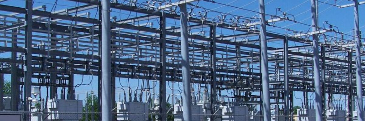
HOLLYWOOD, Fla., Feb. 06, 2025 (GLOBE NEWSWIRE) — NV5 Global, Inc. (the “Company” or “NV5”) (Nasdaq: NVEE), NV5, a provider of technology, certification, and consulting solutions, announced today that it has been awarded $5 million in substation design contracts by Northeast utilities. These projects will strengthen electrical grid reliability and[...]
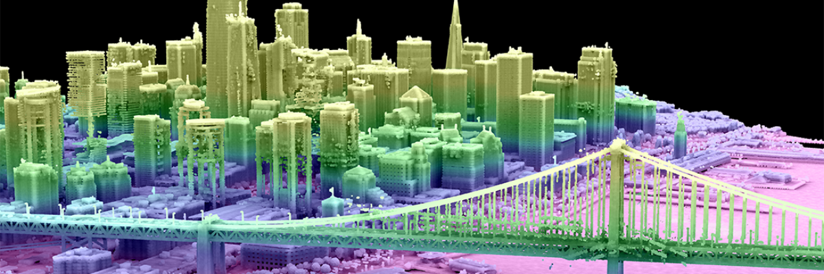
From Digital Twins to Topobathy to AI: NV5 Experts Present Game-Changing Applications for Environmental and Infrastructure Monitoring HOLLYWOOD, Fla., February 5, 2025 – NV5, the world’s leading provider of geospatial software and services, will highlight how government and enterprise organizations solve mission critical challenges using the company’s rich geospatial data[...]
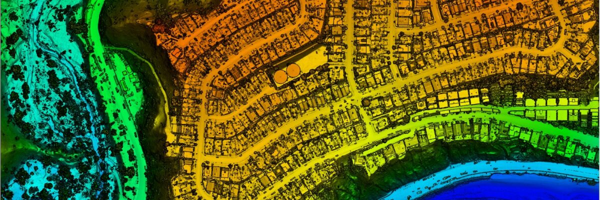
Lidar data collected by NV5 can help quantify fire damage, identify areas at risk of debris flows or flooding, and guide restoration efforts. LOS ANGELES, Calif., January 30, 2025 – NV5, the world’s leading provider of geospatial software and services, today announced that lidar-derived data of the Palisades Fire and[...]
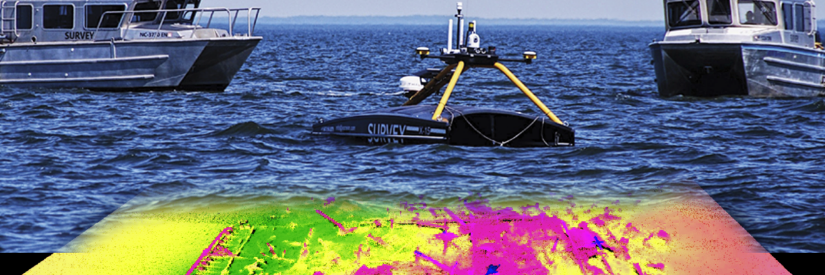
Albemarle Sound Hydrographic Survey The Albemarle Sound, one of the longest estuaries in North Carolina, spans from the Outer Banks to expansive wetlands, rivers, and marshes. NOAA’s Office of Coast Survey (OCS) contracted NV5 to survey the bathymetry of the Sound, a region that hadn’t been surveyed for navigation or[...]
Hollywood, FL – January 24, 2024 – NV5, a provider of technology, certification, and consulting solutions, announced today that it has been awarded a $4 million contract to provide geospatial hydrographic data for approximately 20% of New Zealand’s coastline by Toitū Te Whenua Land Information New Zealand (LINZ), the public[...]
Hollywood, Florida – NV5 (NYSE: NVEE) was selected by the National Geospatial-Intelligence Agency as one of the vendors for the $200 million Luno B commercial data indefinite delivery, indefinite quantity contract. Luno B will provide the national security community with timely access to high-quality commercial GEOINT. The contract will enable[...]
Form #2 - Sends email containing the link to the PDF
"*" indicates required fields
eNewsletter - NV5 Real Estate Transaction Services
Contact NV5 Real Estate Transaction Services
Download NV5 2022 Compliance Calendar
Please fill out the form below. After successful form submission, you will be redirected to the requested file. Thank you.
"*" indicates required fields
Hyperspectral Imaging - Technically Speaking
Our internal innovation and development team constantly analyzes new technology and develops solutions to meet our client’s challenges. Our Technically Speaking series is one way we share our technical findings with the professional community.
Please tell us a little about yourself by filling out the form below, and we’ll share the document with you, thanks!
Accuracy Part 1- Technically Speaking
Our internal innovation and development team constantly analyzes new technology and develops solutions to meet our client’s challenges. Our Technically Speaking series is one way we share our technical findings with the professional community.
Please tell us a little about yourself by filling out the form below, and we’ll share the document with you, thanks!
Prune Optimization Webinar Recording
NV5 Geospatial releases a new predictive modeling platform for vegetation management that uses existing lidar and historical data to identify the relative level of asset risk from trees by quantifying the potential for causing asset damage.
Please tell us a little about yourself by filling out the form below, and we’ll share the document with you, thanks!
Topobathy Lidar - Technically Speaking
Our internal innovation and development team constantly analyzes new technology and develops solutions to meet our client’s challenges. Our Technically Speaking series is one way we share our technical findings with the professional community.
Please tell us a little about yourself by filling out the form below, and we’ll share the document with you, thanks!