Our 1,300+ geospatial employees have deep expertise in lidar, imagery, thermal, SAR, and a variety of advanced sensor technologies.
We have been doing remote sensing for 90+ years and remain the go-to partner for all things geospatial.
We have a proven track record of successful AI engagements across domains.

1. AI Readiness Assessment
This phase assesses existing data, systems, tools, and business processes while identifying GeoAI opportunities aligned with organizational objectives. It also evaluates feasibility, risk, and impact, and includes an AI readiness report and prioritized roadmap for AI adoption.
2. AI Data Implementation
Once opportunities have been identified, this phase helps organizations prepare and optimize their data for AI-enabled workflows. This includes harmonizing raster, vector, tabular, and 3D data; standardizing metadata; evaluating data quality; and establishing governance practices.
3. AI Workflow Development
With a strong data foundation in place, this phase works to deploy AI-driven workflows aligned with business needs. This includes integrating data sources and enterprise systems, implementing analytical processes, and incorporating validation and governance controls.
4. AI Operations and Maintenance
This phase focuses on sustaining and scaling AI capabilities across the organization. It also includes monitoring performance, managing workflows, ensuring compliance, optimizing operations, and supporting user adoption to maximize long-term value.

Generative AI (GeoAgent™)
GeoAgent enables everyone to quickly automate geospatial workflows, generate insights, and make data-driven decisions. It goes beyond simple prompt-responses and understands the full context of a task, dynamically sequencing workflows, and delivering outputs aligned with user intent and project objectives. It dramatically improves productivity by reducing analysis time from hours to minutes. Explore GeoAgent Agentic AI

Spatial Reasoning (GeoIQ™)
GeoIQ is designed to make spatial analysis faster, smarter, and more intuitive. It enables users to interact with geographic data using natural language. They can ask complex questions about spatial patterns, proximity, clustering, and relationships without needing to code or use specialized GIS software. Simply put its like ChatGPT for GIS. See How GeoIQ Simplifies Spatial Reasoning
Data Science & AI
NV5’s Data Science & AI solutions empower organizations to unlock actionable insights from both structured and unstructured geospatial data, driving efficiency, automation, and informed decision-making. NV5 develops custom solutions that recognize patterns across single large datasets or a repository of data holdings and add value by providing additional insights to data previously collected for a single specific use.

DL & LLM
NV5’s Deep Learning (DL) and Large Language Model (LLM) solutions combine advanced AI with deep geospatial expertise to unlock contextual, location-aware insights from complex data sources. NV5 delivers secure, custom LLM deployments that empower organizations to move beyond basic search and manual data management, enabling smarter, faster decision-making across geospatial workflows.
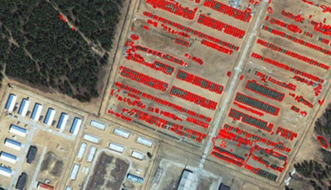
Accelerating Feature Extraction with AI
A U.S. military organization partnered with NV5 to enhance geospatial analysis through AI. Analysts used automated workflows to label features, train models, and rapidly generate outputs, significantly reducing manual effort and accelerating insight generation. The success of this effort has led to follow-on projects and deeper AI integration.
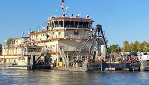
U.S. Army Corps of Engineers - Smart Dredging with AI and Machine Learning
NV5 developed automated tools to validate sensor data from dredging vessels and trained ML models to accurately identify dredge states across multiple inputs, enhancing accuracy and reducing manual review. Natural Language Processing (NLP) tools now extract coordinates and insights from legacy documents, accelerating policy and planning decisions.
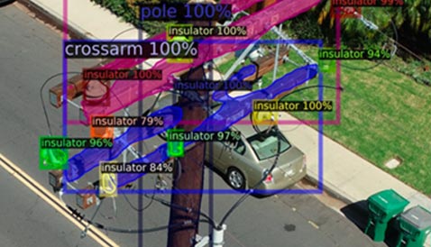
Using AI to Rapidly Extract Utility Assets Across 68,000 Miles of Network
NV5 leveraged its in-house deep learning/AI infrastructure to rapidly and accurately extract utility specific assets from spherical imagery and point clouds across >68,000 miles of a distribution network for a large utility in the Northeast US. By rapidly extracting a network asset model in a timely manner, all operational functions from designing to building to maintenance have become more efficient, effective, and reliable.