The defense and intelligence community is entering a new era of autonomy, one defined by AI-driven workflows that are reshaping how we handle geospatial intelligence (GEOINT). Agents are beginning to perform an ever-growing share of routine GEOINT tasks, including data triage, geospatial analysis, and full intelligence-product creation, and they do[...]
Join us for Geo Sessions, a premier online thought leadership event happening September 16–18. This three-day event welcomes over 20 experts from public organizations, academia, and commercial industries to explore the latest trends, benefits, techniques, and applications of geospatial data and analysis. Each day features a dedicated 2-hour session focused[...]
In the field of fire protection, codes and standards are crucial. They create a framework for life safety, consistency, and compliance. But what happens when a real-world situation doesn’t fit perfectly into the codebook? That’s where engineering judgments (EJ) come into play—and where NV5 offers clarity and confidence. What is[...]
HOLLYWOOD, Fla., July 11, 2025 (GLOBE NEWSWIRE) — NV5, a provider of tech-enabled engineering, certification, and consulting solutions, announced today its acquisition of Professional Systems Engineering, LLC, (PSE) a leading designer of facility technologies for corrections and public safety infrastructure throughout the Northeast. Founded in 1986, PSE’s engineers and consultants[...]
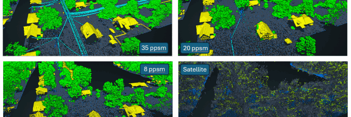
In the remote sensing industry, we’re observing a growing market demand for lower-cost, lower-resolution solutions. This raises a critical question: what level of accuracy is being sacrificed with the lower resolutions, and can we strike the right balance between cost and performance to meet client needs? To explore this within[...]
Form #2 - Sends email containing the link to the PDF
"*" indicates required fields
eNewsletter - NV5 Real Estate Transaction Services
Contact NV5 Real Estate Transaction Services
Download NV5 2022 Compliance Calendar
Please fill out the form below. After successful form submission, you will be redirected to the requested file. Thank you.
"*" indicates required fields
Hyperspectral Imaging - Technically Speaking
Our internal innovation and development team constantly analyzes new technology and develops solutions to meet our client’s challenges. Our Technically Speaking series is one way we share our technical findings with the professional community.
Please tell us a little about yourself by filling out the form below, and we’ll share the document with you, thanks!
Accuracy Part 1- Technically Speaking
Our internal innovation and development team constantly analyzes new technology and develops solutions to meet our client’s challenges. Our Technically Speaking series is one way we share our technical findings with the professional community.
Please tell us a little about yourself by filling out the form below, and we’ll share the document with you, thanks!
Prune Optimization Webinar Recording
NV5 Geospatial releases a new predictive modeling platform for vegetation management that uses existing lidar and historical data to identify the relative level of asset risk from trees by quantifying the potential for causing asset damage.
Please tell us a little about yourself by filling out the form below, and we’ll share the document with you, thanks!
Topobathy Lidar - Technically Speaking
Our internal innovation and development team constantly analyzes new technology and develops solutions to meet our client’s challenges. Our Technically Speaking series is one way we share our technical findings with the professional community.
Please tell us a little about yourself by filling out the form below, and we’ll share the document with you, thanks!