How GIS Can Be Used in the Transportation Planning Phase
In order to pull off transportation projects that improve safety and efficiency for travelers, the planning phase is critical. There are massive amounts of data
In order to pull off transportation projects that improve safety and efficiency for travelers, the planning phase is critical. There are massive amounts of data

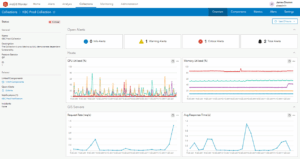
Tualatin Valley Water District (TVWD) is taking a data-driven approach to capital planning, using ArcGIS Utility Network and custom tracing tools developed with NV5 to
NV5, a leading provider of geospatial, professional and technical engineering and consulting solutions, is proud to announce the expansion of its environmental and geospatial capabilities

In the Defense and Intelligence community, the word “stovepipes” has long described one of the greatest barriers to speed and clarity. Each intelligence discipline (e.g.,
Organizations everywhere are working toward AI-driven operations, but legacy and on-prem systems often stand in the way. Trimble Unity changes that. It’s not just another

Helping Infrastructure, Transportation and Utility Leaders Stay Ahead of Landslides, Subsidence, and Slope Failures Geohazards such as slope instability, erosion, settlement, or seepage pose ongoing
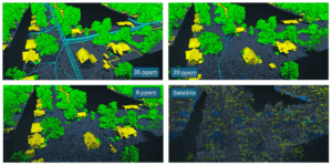
In the remote sensing industry, we’re observing a growing market demand for lower-cost, lower-resolution solutions. This raises a critical question: what level of accuracy is
Challenge KBC Advisors, a fast-moving full-service real estate advisory firm, relies on ArcGIS Enterprise to deliver location-driven insights to its national network of brokers and

View our June edition to learn about our latest geospatial projects. CLICK HERE. June Newsletter

Executive Summary When the world’s busiest airport needed to modernize its GIS and asset management capabilities, NV5 delivered. Through a multi-agency partnership with the City