Gaps in VM Analysis Causing Major Issues

Don’t overlook these 3 areas 

We have specific solutions that assess risk to jumper wires, tower cages, and substations; these analyses can be performed on new or existing hi-res lidar datasets.

Jumper Wires

Jumper wires as well as other auxiliary wires such as vertical conductors are often omitted from VM analysis, leaving vulnerable assets unassessed and creating the possible of system failure. We perform specific analysis on these assets to ensure your entire energized system as been evaluated for encroachment and overstrike threats.

Tower/Structures

We evaluate surrounding vegetation to determine susceptibility of falling into towers, structures, guy wires, or under-build that may result in tower/structure failure and cause an outage.   

Substations

No comprehensive assessment is complete without vegetation management of substations, which includes identification of fall-ins and grow-ins as well as a defensible space review.

Contact Us

Utility VM Analysis

Learn how geospatial data and analytics improves safety and operational efficiency for airport management

Elevate your Operations

Learn More
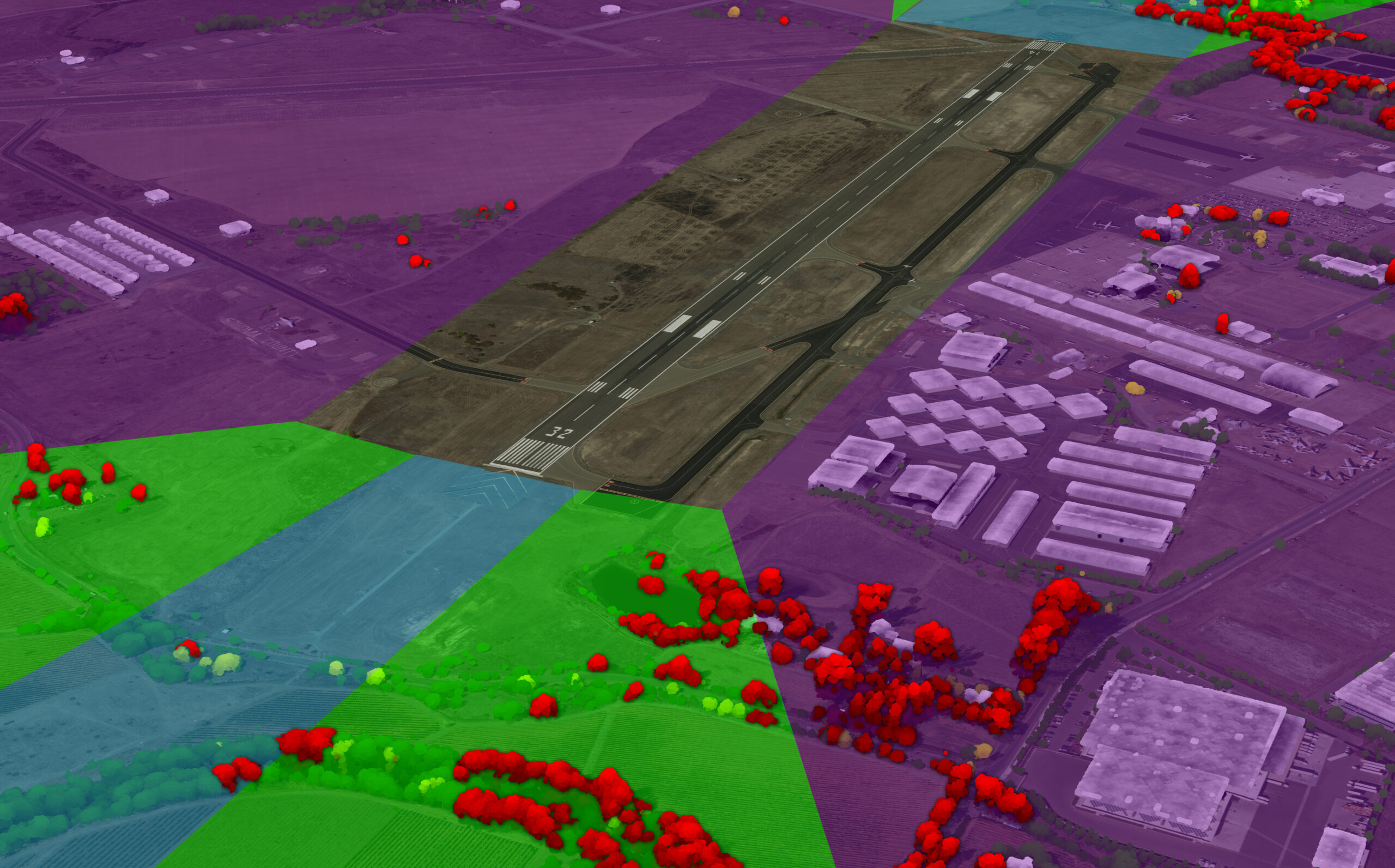
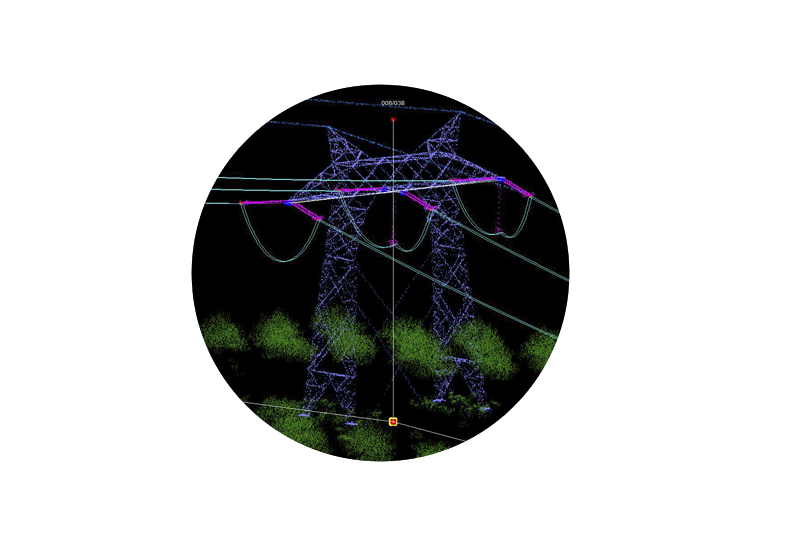
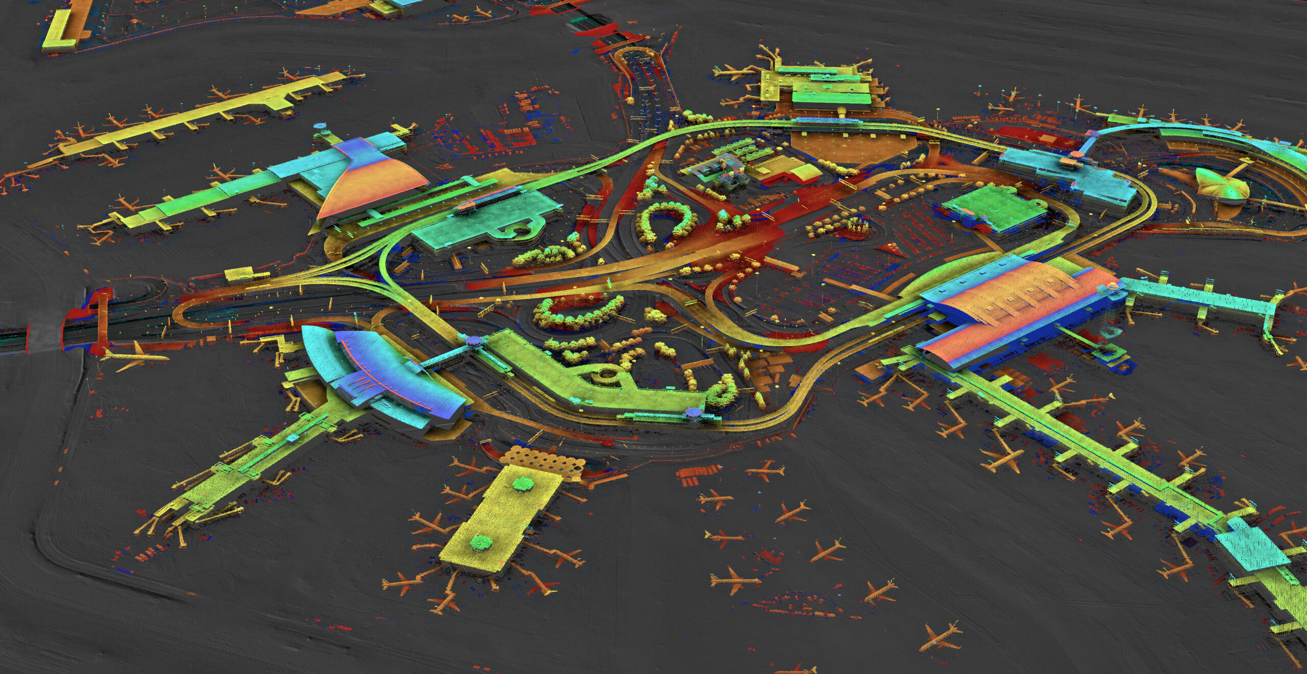
Our innovative obstruction analysis utilizes lidar data to pinpoint airport risk

Identify and Mitigate Risk

Watch Video
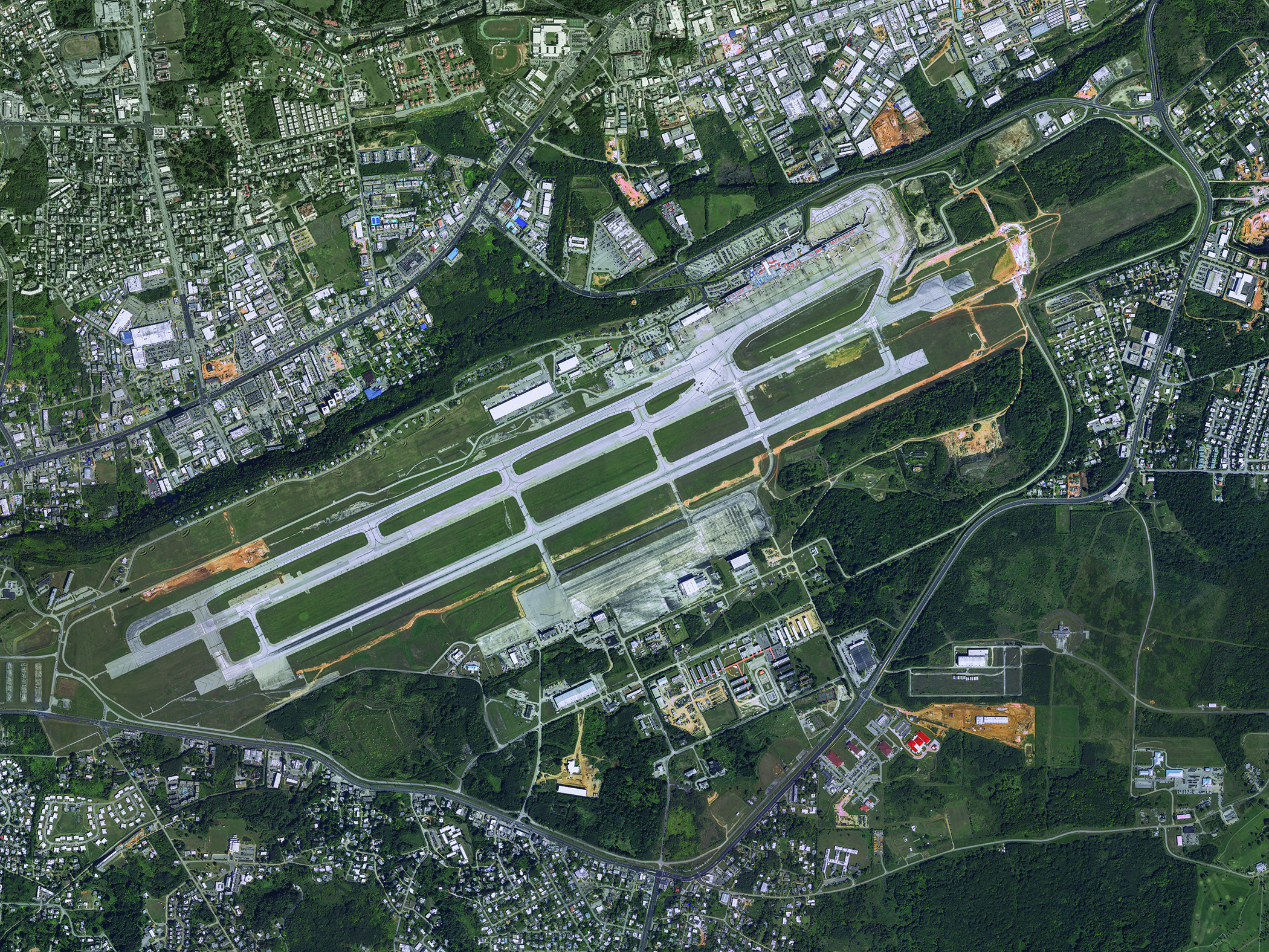
Dive into how geospatial data for airports are collected, analyzed, and used for applications like obstruction analysis, airport mapping, and even pavement management and crack assessment, as well as interior mapping with Bob Vander Meer is vice president of business development for NV5 Geospatial on Airplane Geeks Podcast

Geospatial solutions w/ Airplane Geeks

Listen Here

NV5 Geospatial has been a trusted partner to airport planners, engineers, facility managers, and contractors whose objective is to build, expand, and to make improvements while meeting FAA regulatory and safety requirements. We have more than five decades of experience providing industry leading geospatial services and solutions to hundreds of airports and airfields. We have completed hundreds of ALP projects across the United States including our US territories (Guam, Puerto Rico, and the Northern Mariana Islands). Our clients trust us because we provide accurate data to meet their and the FAA’s expectations. 

Master Plans & ALPs

Better manage airport improvement and expansion. Our airport GIS services include high-accuracy base-map generation, image and elevation data acquisition, airspace analysis for vertically and non-vertically guided runways, and mapping and attribution for Airport Layout Plans (ALPs) and eALPs. We were the first geospatial services firm in the nation to deliver an eALP project to the FAA and have it approved. NV5 Geospatial is at the forefront in providing airport planners, engineers, and facility managers with high accuracy topographic maps, planimetric maps, aerial imagery, and analytics to meet the Federal Aviation Administration’s Advisory Circulars: AC 150/5300-16, 17, and 18. Services include imagery acquisition, ground survey, digital orthophotography,high-accuracy base-map generation, airspace analysis for vertically and non vertically guided runways, and mapping and attribution for Airport Layout Plans (ALPs).

Engineering Design Mapping and Surveys

Provide airport engineers with the proper information for any runway, taxiway, or airport design need. Our airport GIS services off solutions including engineering-grade mapping, engineering surveys, aeronautical surveys, and as-built documentation, all delivered in accordance with the FAA’s Advisory Circulars.

Obstruction Analysis

Identify and mitigate obstruction hazards so that aircraft can safely approach, land, and depart from an airport. We can provide an up-to-date status of runway approaches and detect obstructions such as treetops, poles, towers, antennas, buildings, and other structures in accordance with FAA requirements.

Vegetation Management

Comply with recent FAA clearance requirements and execute safe and reliable night flights and airport approaches. Our best-in-class vegetation management solutions include clearance detection and minimum clearance analytics, hazard tree detection, and change detection.

Resources

Related Links

Contact Us

Fill out the form below to download the handbook.

Form #1 - Redirection to PDF

Form #2 - Sends email containing the link to the PDF

"*" indicates required fields

This field is for validation purposes and should be left unchanged.

eNewsletter - NV5 Real Estate Transaction Services

Contact NV5 Real Estate Transaction Services

Download NV5 2022 Compliance Calendar

Please fill out the form below. After successful form submission, you will be redirected to the requested file. Thank you.

  • We are an equal opportunity employer. All applicants will be considered for employment without attention to race, color, religion, sex, sexual orientation, gender identity, national origin, veteran or disability status. We ensure nondiscrimination in all programs and activities in accordance with Title VI of the United States Civil Rights Act of 1964. If you need more information or special assistance for persons with disabilities or limited English proficiency, contact MaryJo OBrien at (954) 495-2112. Persons with hearing-and speech-impairments can contact the NV5 by using the Virginia Relay Service, a toll-free telecommunication device for the deaf (TDD). Call 711 for TTY/TDD.

Hyperspectral Imaging - Technically Speaking

Our internal innovation and development team constantly analyzes new technology and develops solutions to meet our client’s challenges. Our Technically Speaking series is one way we share our technical findings with the professional community. 

Please tell us a little about yourself by filling out the form below, and we’ll share the document with you, thanks!

Accuracy Part 1- Technically Speaking

Our internal innovation and development team constantly analyzes new technology and develops solutions to meet our client’s challenges. Our Technically Speaking series is one way we share our technical findings with the professional community. 

Please tell us a little about yourself by filling out the form below, and we’ll share the document with you, thanks!

Prune Optimization Webinar Recording

NV5 Geospatial releases a new predictive modeling platform for vegetation management that uses existing lidar and historical data to identify the relative level of asset risk from trees by quantifying the potential for causing asset damage. 

Please tell us a little about yourself by filling out the form below, and we’ll share the document with you, thanks!

Topobathy Lidar - Technically Speaking

Our internal innovation and development team constantly analyzes new technology and develops solutions to meet our client’s challenges. Our Technically Speaking series is one way we share our technical findings with the professional community. 

Please tell us a little about yourself by filling out the form below, and we’ll share the document with you, thanks!

Contact Geospatial

Contact Geospatial