Commissioning services for the UMass Amherst’s Isenberg School of Management Business Innovation Hub. The 70,000 SF addition includes classroom and lab spaces, faculty offices, career center, and a new learning commons and event center. The new Hub connects to the existing Isenberg building. Services included: commissioning plan development, design review,[...]
Commissioning services for the renovation/expansion of Dana Hall. The four-story academic and faculty office building was expanded from 26,000 SF to 32,995 SF and includes a computer science classroom, graduate study lounge, a small café, seminar space conference rooms and offices. Project is seeking LEED v4 with a goal of[...]
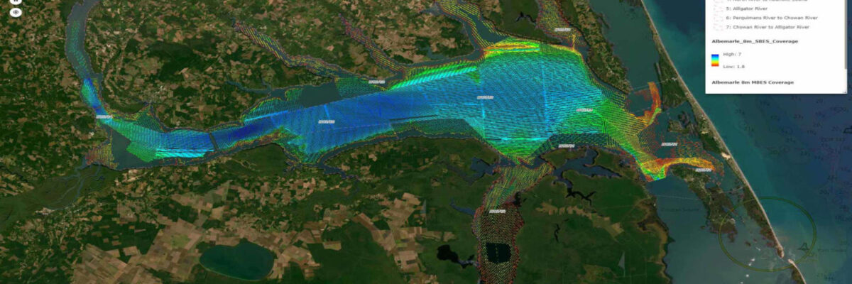
Task Order Features Unique Survey Approach to Deliver Valuable Charting Data that Will Also Support Environmental and Coastal Resilience Efforts Geodynamics, an NV5 company, North America’s most comprehensive geospatial data provider, has undertaken one of the largest surveys of shallow complex environments under a dual purpose task order from the[...]
Form #2 - Sends email containing the link to the PDF
"*" indicates required fields
eNewsletter - NV5 Real Estate Transaction Services
Contact NV5 Real Estate Transaction Services
Download NV5 2022 Compliance Calendar
Please fill out the form below. After successful form submission, you will be redirected to the requested file. Thank you.
"*" indicates required fields
Hyperspectral Imaging - Technically Speaking
Our internal innovation and development team constantly analyzes new technology and develops solutions to meet our client’s challenges. Our Technically Speaking series is one way we share our technical findings with the professional community.
Please tell us a little about yourself by filling out the form below, and we’ll share the document with you, thanks!
Accuracy Part 1- Technically Speaking
Our internal innovation and development team constantly analyzes new technology and develops solutions to meet our client’s challenges. Our Technically Speaking series is one way we share our technical findings with the professional community.
Please tell us a little about yourself by filling out the form below, and we’ll share the document with you, thanks!
Prune Optimization Webinar Recording
NV5 Geospatial releases a new predictive modeling platform for vegetation management that uses existing lidar and historical data to identify the relative level of asset risk from trees by quantifying the potential for causing asset damage.
Please tell us a little about yourself by filling out the form below, and we’ll share the document with you, thanks!
Topobathy Lidar - Technically Speaking
Our internal innovation and development team constantly analyzes new technology and develops solutions to meet our client’s challenges. Our Technically Speaking series is one way we share our technical findings with the professional community.
Please tell us a little about yourself by filling out the form below, and we’ll share the document with you, thanks!