How Long Should a Zoning Report Take to Prepare? – Tips for Quick Reports During most commercial real estate transactions, it is likely that the surveyor, lender or title company will require some type of zoning report. In this post, we will offer insight into how long it takes to[...]
Quantum Spatial is at the Alaska Survey and Mapping Conference in Anchorage. We are excited to share some of our recent work in remote sensing acquisition and analytics, including thermal infrared imaging, precise point positioning acquisition, topobathy LiDAR, and eGIS solutions. Additionally we look forward to meeting new people, reuniting[...]
John Bills, NV5’s Chief Operating Officer – Program Management, has been selected as one of the “Top 20 Under 40” winners in the Engineering News-Record (ENR) Mountain States Top Young Professionals competition, which recognizes up-and-coming industry leaders. Professionals from the nine-state region were nominated and judged on their career experience,[...]
Quantum Spatial, Inc. the nation’s largest independent geospatial data firm, will showcase its leadership in use of next-generation sensors to support wide-area programs, such as the U.S. Geological Survey (USGS) 3D Elevation Program (3DEP), topographic-bathymetric (topo-bathy) LiDAR and unmanned aerial vehicles (UAVs) at the International LiDAR Mapping Forum (ILMF) next[...]
Quantum Spatial, Inc. the nation’s largest independent geospatial data firm, will showcase its industry-leading use of topographic-bathymetric (topo-bathy) LiDAR and advanced analytics to support natural resource managment by public agencies in presentations and exhibits at the Coastal GeoTools conference next week. Join our experts at GeoTools in North Charleston Feb[...]
HOLLYWOOD, FL — (Marketwired) — 02/02/17 — NV5 Global, Inc. (the “Company” or “NV5”) (NASDAQ: NVEE), a provider of professional and technical engineering and consulting solutions, will announce its financial results for the fourth quarter and year ended December 31, 2016 on Thursday, March 9, 2017, following the close of[...]
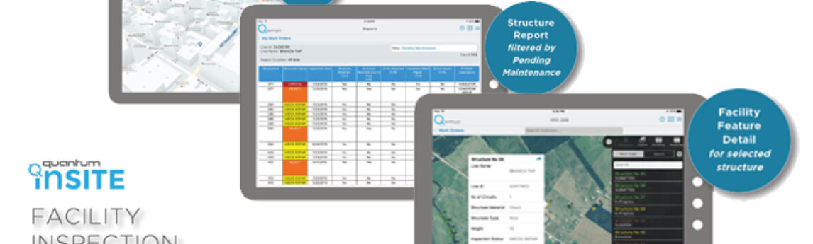
What if you could answer questions and tackle changes in your distribution system before they become problems? Distribution Network Intelligence builds foundationally on geospatial analytics to quantify structural deficits, manage vegetation, and track linear asset inspection progress against your mandated facilities inspection program. These are just some of the waysQuantum[...]
By Barrett Buechler New community solar programs, combined with utility- scale and rooftop solar projects, are expected to drive the growth of solar energy in 2016 by 119%, according to a quarterly report published by GTM Research and the Solar Energy Industries Association.1 GTM Research backs its forecast numbers by[...]
March 16, 2016 By CARL GLASSMAN / TribecaTribOnline Plans are afoot to make pedestrian-unfriendly Water Street more welcoming. New plaza designs, wider sidewalks and a unified streetscape are among the features slated for the street’s five southern-most blocks—between Whitehall Street and Hanover Square. “This is the beginning of our efforts[...]
Sometimes it’s the smallest details that cause the biggest of problems. Those big problems can hold up a real estate closing, purchase or financing. In this post, we will offer some tips to help you avoid these issues. Provide the Right Information When ordering your Environmental and Property Condition Assessments,[...]
Form #2 - Sends email containing the link to the PDF
"*" indicates required fields
eNewsletter - NV5 Real Estate Transaction Services
Contact NV5 Real Estate Transaction Services
Download NV5 2022 Compliance Calendar
Please fill out the form below. After successful form submission, you will be redirected to the requested file. Thank you.
"*" indicates required fields
Hyperspectral Imaging - Technically Speaking
Our internal innovation and development team constantly analyzes new technology and develops solutions to meet our client’s challenges. Our Technically Speaking series is one way we share our technical findings with the professional community.
Please tell us a little about yourself by filling out the form below, and we’ll share the document with you, thanks!
Accuracy Part 1- Technically Speaking
Our internal innovation and development team constantly analyzes new technology and develops solutions to meet our client’s challenges. Our Technically Speaking series is one way we share our technical findings with the professional community.
Please tell us a little about yourself by filling out the form below, and we’ll share the document with you, thanks!
Prune Optimization Webinar Recording
NV5 Geospatial releases a new predictive modeling platform for vegetation management that uses existing lidar and historical data to identify the relative level of asset risk from trees by quantifying the potential for causing asset damage.
Please tell us a little about yourself by filling out the form below, and we’ll share the document with you, thanks!
Topobathy Lidar - Technically Speaking
Our internal innovation and development team constantly analyzes new technology and develops solutions to meet our client’s challenges. Our Technically Speaking series is one way we share our technical findings with the professional community.
Please tell us a little about yourself by filling out the form below, and we’ll share the document with you, thanks!