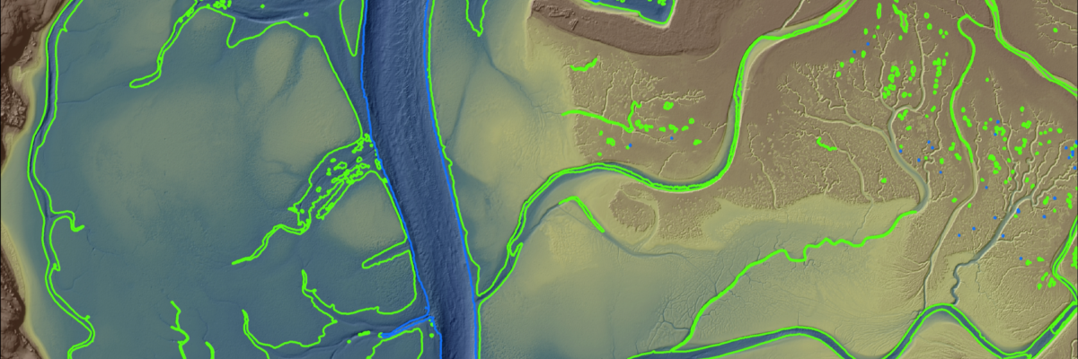
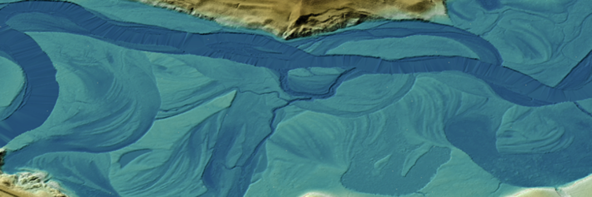
The Hydrospatial Data Collection Approach in Morro Bay – By Steve Raber, Ann Kitajima, Carolyn Geraghty Morro Bay, a shallow coastal estuary located near San Luis Obispo, California, supports an abundance of wildlife and is home to a vibrant outdoor community. But changes – such as sedimentation and a substantial[...]
-by Ian Bryan Hoffman, AIA Room acoustic design for performance and assembly spaces continues to be a rich and engaging pursuit that bridges technical analysis with a healthy understanding of human aural perception and building design. Relatively speaking, room acoustics remains a young field – just more than 120 years[...]
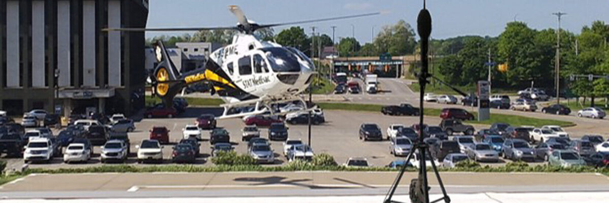
-by Justin Meyer, LEED AP, INCE As acousticians, we get to see and hear a wide array of interesting things that many people don’t. It may be taking sound level measurements of wind turbines scattered across rolling hills, the manufacturing process of a consumer staple that we all have in[...]
– by Julie Fischer INCE, LEED AP BD+C Although acoustics is one of the top complaints in occupied buildings, it is typically a secondary consideration due to its non-visual nature. In some cases, acoustical design provides an overall auditory improvement to a space. In other cases, acoustics can have a[...]
By Spencer O’Quinn NV5’s Saint Paul office recently started a formal mentorship program. This program was initiated months ago with the purpose of investing in our employees to improve the employee experience and increase retention through engagement and skills development, and to encourage building professional networks in the pandemic age.[...]
Projects include work with NOAA, USGS, Alaska Railroad Corporation, Alaska Department of Natural Resources, U.S. Fish and Wildlife and the U.S. Department of Agriculture ANCHORAGE, Alaska –July 5, 2022, NV5 Geospatial, the largest geospatial services provider in North America, marks its 65th year helping Alaska solve a number of its[...]
WHAT IS DECARBONIZATION? We are all familiar with the technical definition of decarbonization: it is the reduction of carbon dioxide emissions using low carbon power sources, achieving a lower output of greenhouse gasses into the atmosphere. But what does decarbonization actually mean? Generally speaking, it tends to refer to the[...]
Since ancient times, humans have always been looking for a way to store energy or construct some form of what is now called ‘batteries’. The oldest battery discovered to date is the Baghdad (or Parthian) battery, which we believe to be 2,000 years old. Although the device could only produce[...]
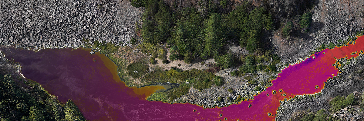
Over the past three decades, thermal infrared technology has spread into a wide range of industries with varied applications including: monitoring river temperatures to promote habitat health, geothermal energy exploration, and bridge deck inspection for early deterioration detection. NV5’s Chris Miwa and Mousa Diabat discuss the technology and applications of[...]
Form #2 - Sends email containing the link to the PDF
"*" indicates required fields
eNewsletter - NV5 Real Estate Transaction Services
Contact NV5 Real Estate Transaction Services
Download NV5 2022 Compliance Calendar
Please fill out the form below. After successful form submission, you will be redirected to the requested file. Thank you.
"*" indicates required fields
Hyperspectral Imaging - Technically Speaking
Our internal innovation and development team constantly analyzes new technology and develops solutions to meet our client’s challenges. Our Technically Speaking series is one way we share our technical findings with the professional community.
Please tell us a little about yourself by filling out the form below, and we’ll share the document with you, thanks!
Accuracy Part 1- Technically Speaking
Our internal innovation and development team constantly analyzes new technology and develops solutions to meet our client’s challenges. Our Technically Speaking series is one way we share our technical findings with the professional community.
Please tell us a little about yourself by filling out the form below, and we’ll share the document with you, thanks!
Prune Optimization Webinar Recording
NV5 Geospatial releases a new predictive modeling platform for vegetation management that uses existing lidar and historical data to identify the relative level of asset risk from trees by quantifying the potential for causing asset damage.
Please tell us a little about yourself by filling out the form below, and we’ll share the document with you, thanks!
Topobathy Lidar - Technically Speaking
Our internal innovation and development team constantly analyzes new technology and develops solutions to meet our client’s challenges. Our Technically Speaking series is one way we share our technical findings with the professional community.
Please tell us a little about yourself by filling out the form below, and we’ll share the document with you, thanks!