Expert NV5 Speakers to Present on Bathymetric Lidar, Airborne Mapping, Remote Sensing Innovation, Photogrammetry, ASPRS Standards, and the Future of Geospatial Intelligence
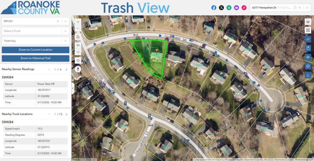
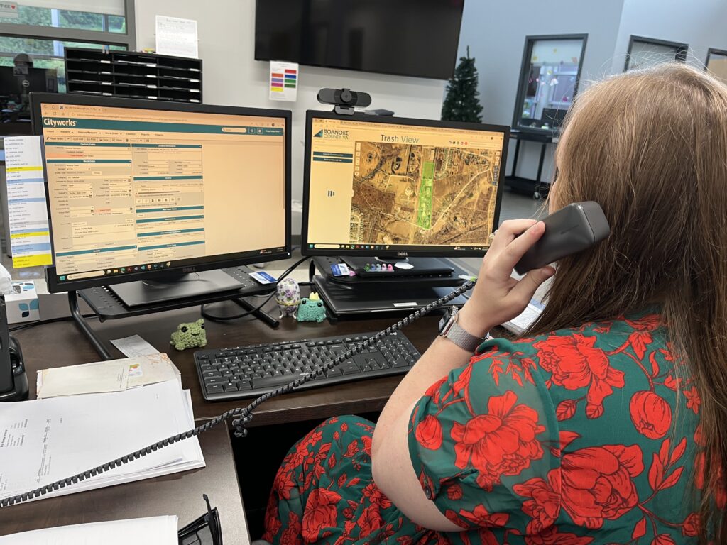
Roanoke County, VA, in collaboration with NV5, is pioneering a data-driven approach to waste management by integrating real-time tracking, predictive analytics, and sensor-based monitoring into trash collection operations. Using Esri ArcGIS Experience Builder (ExB) Developer Edition, the County has developed TrashView, an innovative application that enhances operational efficiency, improves fleet management, and provides residents with greater transparency about waste collection services.
By replacing outdated GIS tools with scalable, customizable, and interactive solutions, NV5 was able to position Roanoke County to take a major step forward in modernizing public services and laying the groundwork for future smart county initiatives.
The Challenge: Outdated Systems & Inefficient Waste Management
The Roanoke County landscape of GIS solutions was built on legacy JavaScript applications, many of which were becoming obsolete as Esri and other vendors transitioned to modern web technologies. Without an upgrade path, these aging systems posed security risks, limited scalability, and inefficiencies in maintaining a suite of disconnected applications spanning multiple departments. The County needed a future-proof, integrated GIS solution that could support real-time data, fleet tracking, and IoT sensor integration.
At the same time, Roanoke County faced significant challenges in waste collection and fleet management, including:
· Lack of real-time visibility into trash collection routes and fleet operations.
· Unclear maintenance needs for critical components like arms and packers made it difficult to schedule preventive service, leading to unexpected failures and increased repair costs.
· Limited data for optimizing routes, causing unnecessary fuel consumption and delays.
· Tool to inform customer services and residents about pickup schedules and service updates.
To improve efficiency, reduce costs, and enhance public services, the County required a scalable, GIS-powered solution that could integrate real-time intelligence into waste collection while modernizing its overall GIS infrastructure.
The Partner: NV5 & Esri ArcGIS Experience Builder
Roanoke County partnered with NV5, relying on their expertise leveraging the Esri ArcGIS Experience Builder to create a fully configured, data-driven solution.
NV5 worked closely with the County’s GIS and Waste Management teams to:
· Customize Experience Builder to integrate IoT sensor data, fleet telematics, and predictive analytics.
· Ensure scalability to allow the same technology to be expanded to other public services.
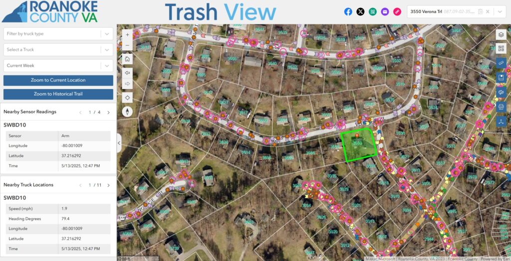
· Enable real-time and historical tracking of waste collection activities.
· Create a user-friendly interface for internal operations.
This collaboration resulted in a solution designed to seamlessly manage both internal fleet operations and citizen engagement, a critical step toward improving waste collection efficiency.
The Solution: TrashView – A Data-Driven Approach to Waste Management
Key Features & Benefits:
· Real-Time Truck Tracking – Monitors garbage truck locations and collection status, providing visibility into daily operations.
· Sensor-Based Telematics – Tracks side-loading arm usage, compaction cycles, and vehicle diagnostics to optimize fleet performance.
· Predictive Maintenance – Analyzes equipment usage to prevent breakdowns, extend vehicle lifespans, and reduce maintenance costs.
· Smart Fleet Optimization – Ensures balanced workloads across vehicles, reducing fuel costs and improving route efficiency.
Innovative Technology Integration
Virginia Tech students played a key role in installing IoT sensors on trash trucks, allowing the County to monitor:
· How often the collection arm is used (to schedule preventive maintenance).
· When a truck completes its assigned route (ensuring timely pickups).
· Total mileage per truck (for balanced fleet utilization).
By combining sensor data with GIS analytics, Roanoke County can identify inefficiencies, extend vehicle lifespans, and optimize collection schedules, leading to lower costs and better service for residents.
The Results: A Smarter, More Efficient Waste Management System
Since implementing TrashView, Roanoke County has seen significant improvements in its waste management operations:
· Reduced vehicle downtime – Early maintenance detection prevents costly breakdowns.
· Improved route efficiency – GIS-powered tracking optimizes collection schedules.
· Increased operational visibility – Real-time data helps waste management teams make informed decisions.
· Enhanced citizen engagement – Residents gain better insight into pickup schedules and service updates.
Although the project is still in its early stages, Roanoke County expects long-term cost savings, better fleet management, and improved public service efficiency as TrashView continues to evolve.
“Working with NV5 and Esri’s Experience Builder, we were able to deliver a solution that integrates seamlessly with our operations - configured for Roanoke County’s needs and scalable for what comes next.”
— David Wray, GIS Manager, Roanoke County
Looking Ahead: Expanding Smart GIS Solutions
With the success of TrashView, Roanoke County is exploring ways to expand GIS-based, smart city solutions across multiple departments. Potential next steps include:
· Expanding real-time tracking to other County services, such as emergency response, transportation planning, and real estate property management.
· Integrating AI-powered work order automation to predict maintenance needs, improve fleet efficiency, and support asset management.
· Enhancing TaxView for real estate assessments, enabling residents and staff to access recent property sales, parcel valuations, tax records, and land-use statistics in a centralized GIS platform.
· Developing public dashboards to improve citizen engagement by providing real-time data on property trends, land value changes, and other tax-related insights.
By continuing to innovate with NV5 and Esri technology, Roanoke County is setting a new standard for data-driven public service operations. This collaboration proves that smart GIS solutions can create more efficient, transparent, and connected communities.
Interested in modernizing waste management or other municipal services with GIS-powered solutions? Contact NV5 today to discover how our Esri Experience Builder expertise can transform your operations.