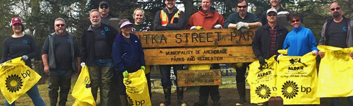
Quantum Spatial was out in force, participating in Anchorage Waterways Council’s Creek Cleanup. The volunteer crew got their feet wet, literally, as they removed trash from Chester Creek flowing through Sitka Street Park. Good times were had by all and a cookout provided a satisfying conclusion to a hard day’s[...]
Requirements for New Property Description on the ALTA Land Survey? The 2016 Minimum Standard Detail Requirements for ALTA Surveys states in Section 6.B.ii that the surveyor now has additional responsibilities when presenting a NEW “As-Surveyed” property description on the front of the survey. What Does this New Property Description Mean?[...]
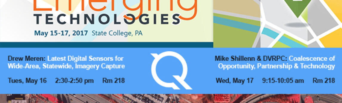
We’re excited to attend the PA GIS Conference, from May 15-17. We’re looking forward to learn more about emerging technologies across the industry as well as sharing some of our own insights and innovations including our work with orthoimagery, LiDAR, and eGIS analytics and applications. Attend one of our presentations,[...]
We had a busy year in 2016, collecting, processing, and analyzing a wide variety of data across all 50 states and applied to a diverse group of public and private industries such as coastal management, forestry, utilities management, and aviation.
HOLLYWOOD, Fla., May 04, 2017 (GLOBE NEWSWIRE) — NV5 Global, Inc. (Nasdaq:NVEE) (“NV5” or the “Company”), a provider of professional and technical engineering and consulting solutions, today reported financial results for the first quarter ended April 1, 2017. The Company also announced the acquisition of Holdrege & Kull, Consulting Engineers[...]
By Tarika Hanawalt While many governments and organizations use the geospatial data we provide, what the public sees is often just a detailed map or two. And if they do make all the datasets public, it can take months, if not years, before others can access it. But that’s not[...]
By Kurt Allen, Quantum Spatial Vice President Federal Vertical Lead After witnessing firsthand the devastation landslides cause across a number of states, including Alaska, California and Washington, we believe the bipartisan, bicameral National Landslide Preparedness Act recently announced by Sen. Marie Cantwell (D-Wash.) and Sen. Lisa Murkowski (R-Alaska), ranking member[...]
HOLLYWOOD, Fla., April 20, 2017 (GLOBE NEWSWIRE) — NV5 Global, Inc. (the “Company” or “NV5”) (Nasdaq:NVEE), a provider of professional and technical engineering and consulting solutions, will announce its financial results for the first quarter ended April 1, 2017 on Thursday, May 4, 2017, following the close of the markets.[...]
Written by Steve Raber, Quantum Spatial Senior Program Manager April 20th marks the day when, seven years ago, BP’s offshore drilling rig Deepwater Horizon suffered a catastrophic failure and set off one of the largest oil spills in history. During the nearly five months until the well was declared sealed,[...]
Alternate Measures for Large Properties – Optional Table A Item 15 For ALTA surveys of large properties, it may be beneficial to consider Optional Table A Item 15. Requesting this item frequently benefits the ordering party with both cost savings and shorter time frames to complete the survey work. Item[...]
Form #2 - Sends email containing the link to the PDF
"*" indicates required fields
eNewsletter - NV5 Real Estate Transaction Services
Contact NV5 Real Estate Transaction Services
Download NV5 2022 Compliance Calendar
Please fill out the form below. After successful form submission, you will be redirected to the requested file. Thank you.
"*" indicates required fields
Hyperspectral Imaging - Technically Speaking
Our internal innovation and development team constantly analyzes new technology and develops solutions to meet our client’s challenges. Our Technically Speaking series is one way we share our technical findings with the professional community.
Please tell us a little about yourself by filling out the form below, and we’ll share the document with you, thanks!
Accuracy Part 1- Technically Speaking
Our internal innovation and development team constantly analyzes new technology and develops solutions to meet our client’s challenges. Our Technically Speaking series is one way we share our technical findings with the professional community.
Please tell us a little about yourself by filling out the form below, and we’ll share the document with you, thanks!
Prune Optimization Webinar Recording
NV5 Geospatial releases a new predictive modeling platform for vegetation management that uses existing lidar and historical data to identify the relative level of asset risk from trees by quantifying the potential for causing asset damage.
Please tell us a little about yourself by filling out the form below, and we’ll share the document with you, thanks!
Topobathy Lidar - Technically Speaking
Our internal innovation and development team constantly analyzes new technology and develops solutions to meet our client’s challenges. Our Technically Speaking series is one way we share our technical findings with the professional community.
Please tell us a little about yourself by filling out the form below, and we’ll share the document with you, thanks!