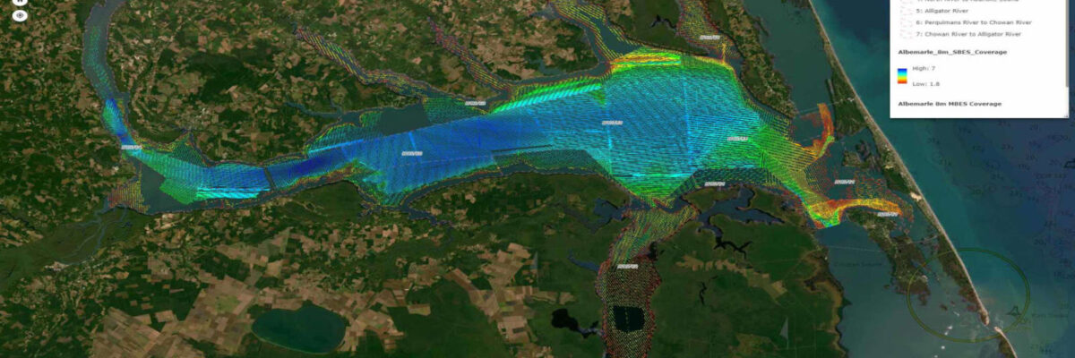
Task Order Features Unique Survey Approach to Deliver Valuable Charting Data that Will Also Support Environmental and Coastal Resilience Efforts Geodynamics, an NV5 company, North America’s most comprehensive geospatial data provider, has undertaken one of the largest surveys of shallow complex environments under a dual purpose task order from the[...]
HOLLYWOOD, Fla., April 10, 2023 (GLOBE NEWSWIRE) — NV5 Global, Inc. (the “Company” or “NV5”) (Nasdaq: NVEE), a provider of technology, conformity assessment, and consulting solutions, announced today the closing of its acquisition of L3Harris Technologies, Inc.’s Visual Information Solutions commercial geospatial technology and software business (“VIS”). First announced in[...]
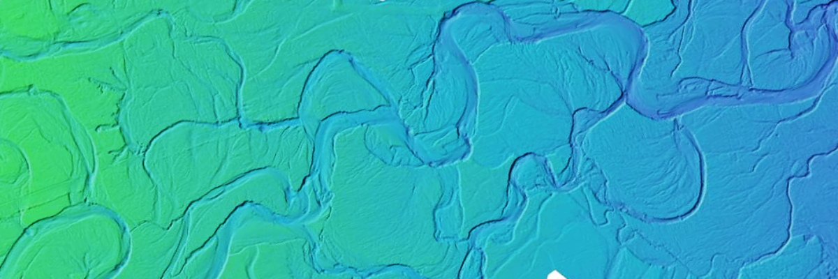
A pioneer in the use of topobathymetric lidar, NV5 Geospatial has mapped a diversity of aquatic landscapes stretching across North America St. Petersburg, Florida – March 22, 2023 – Ten years after completing the company’s first shoreline mapping project, NV5 Geospatial announced today that it has mapped more than 26[...]
NV5 earned the Excellence Award in Surveying/Field Data Collection, announced at the 2023 MAPPS Winter Conference Overview- One of only six hypersaline lagoons in the world, the Laguna Madre is one of the most biologically diverse and undeveloped coastal ecosystems in North America. Covering an area over 1000 km2 along[...]
NV5 Awarded $9 Million NOAA Contract to Support Shoreline Mapping in Maine November 22, 2022 HOLLYWOOD, Fla., Nov. 22, 2022 (GLOBE NEWSWIRE) — NV5 Global, Inc. (the “Company” or “NV5”) (Nasdaq: NVEE), a provider of technology, conformity assessment, and consulting solutions, announced today that it has been awarded a $9[...]
We extend our heartfelt congratulations to our very own Tim Saultz, who was awarded The Distinguished Service Award, the highest honorary recognition an employee can receive within the Department of the Interior. Tim dedicated more than 25 years to the U.S. Geological Survey (USGS) and was essential in developing consistent[...]
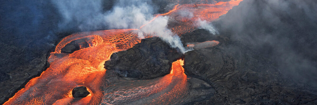
Written by Joel Burroughs, NV5 Geospatial Account Manager When volcanoes erupt, the force of explosions and lava dramatically change the landscape, impacting the geography and the lives of those who live and work nearby. This is especially true on the southern tip of Hawaii, which is home to the world’s[...]
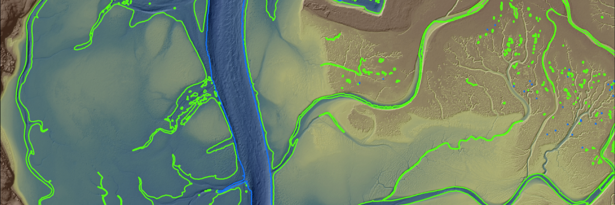
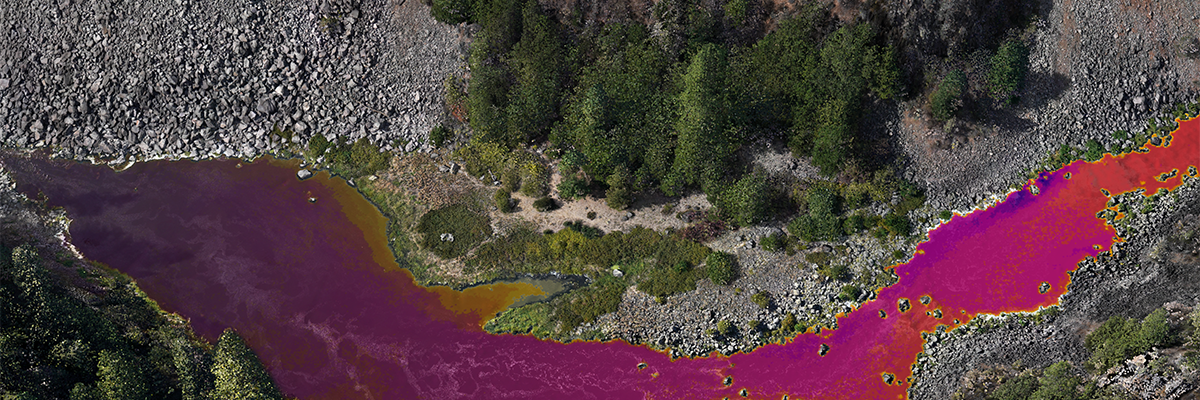
The Hydrospatial Data Collection Approach in Morro Bay – By Steve Raber, Ann Kitajima, Carolyn Geraghty Morro Bay, a shallow coastal estuary located near San Luis Obispo, California, supports an abundance of wildlife and is home to a vibrant outdoor community. But changes – such as sedimentation and a substantial[...]
Projects include work with NOAA, USGS, Alaska Railroad Corporation, Alaska Department of Natural Resources, U.S. Fish and Wildlife and the U.S. Department of Agriculture ANCHORAGE, Alaska –July 5, 2022, NV5 Geospatial, the largest geospatial services provider in North America, marks its 65th year helping Alaska solve a number of its[...]
Over the past three decades, thermal infrared technology has spread into a wide range of industries with varied applications including: monitoring river temperatures to promote habitat health, geothermal energy exploration, and bridge deck inspection for early deterioration detection. NV5’s Chris Miwa and Mousa Diabat discuss the technology and applications of[...]
Form #2 - Sends email containing the link to the PDF
"*" indicates required fields
eNewsletter - NV5 Real Estate Transaction Services
Contact NV5 Real Estate Transaction Services
Download NV5 2022 Compliance Calendar
Please fill out the form below. After successful form submission, you will be redirected to the requested file. Thank you.
"*" indicates required fields
Hyperspectral Imaging - Technically Speaking
Our internal innovation and development team constantly analyzes new technology and develops solutions to meet our client’s challenges. Our Technically Speaking series is one way we share our technical findings with the professional community.
Please tell us a little about yourself by filling out the form below, and we’ll share the document with you, thanks!
Accuracy Part 1- Technically Speaking
Our internal innovation and development team constantly analyzes new technology and develops solutions to meet our client’s challenges. Our Technically Speaking series is one way we share our technical findings with the professional community.
Please tell us a little about yourself by filling out the form below, and we’ll share the document with you, thanks!
Prune Optimization Webinar Recording
NV5 Geospatial releases a new predictive modeling platform for vegetation management that uses existing lidar and historical data to identify the relative level of asset risk from trees by quantifying the potential for causing asset damage.
Please tell us a little about yourself by filling out the form below, and we’ll share the document with you, thanks!
Topobathy Lidar - Technically Speaking
Our internal innovation and development team constantly analyzes new technology and develops solutions to meet our client’s challenges. Our Technically Speaking series is one way we share our technical findings with the professional community.
Please tell us a little about yourself by filling out the form below, and we’ll share the document with you, thanks!