GoGeomatics published a new article that explores how AI-powered geospatial analysis is transforming the way organizations turn data into decisions. Titled, “From Imagery to Insight: How NV5’s GeoAgent™ AI is Reshaping Geospatial Analysis,” the article addresses a growing industry challenge: despite massive advances in remote sensing, many organizations struggle to convert the data that’s collected into actionable insight.
The Shift From Data Collection to Decision Intelligence
As data volumes grow, analysts are increasingly burdened by complex workflows and fragmented systems. This creates a gap between data availability and operational intelligence, resulting in a bottleneck across industries such as utilities, transportation, environmental monitoring, and defense.
The article highlights how agentic AI is emerging as a solution. Unlike traditional geospatial analytics tools, which require manual configuration, NV5’s GeoAgent platform uses AI-driven workflow automation to interpret user intent, plan analytical steps, and execute them automatically.
The result is a new model for geospatial intelligence, one that accelerates the path from raw imagery to insight.
What Is Agentic AI in Geospatial Analysis?
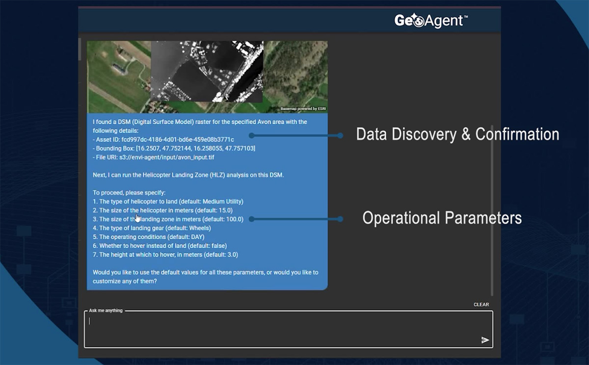
GeoAgent represents a shift from tool-based workflows to outcome-driven geospatial AI. Users interact through natural language, and the system:
- Identifies relevant data sources
- Executes remote sensing analysis workflows
- Generates outputs ready for GIS and operational systems
- Maintains transparency through full audit trails
By combining adaptive AI reasoning with the ENVI® platform, GeoAgent enables faster, more scalable geospatial data processing.
Real-World Applications Across Industries
The article outlines how AI in geospatial analysis is already delivering value across sectors:
- Utilities: Vegetation management, asset extraction, and infrastructure monitoring
- Transportation: Corridor analysis and land-use change detection
- Environmental Monitoring: Climate tracking and ecosystem analysis
- Emergency Response: Rapid damage assessment and situational awareness
- Defense: Terrain analysis and mission planning
In each case, automated geospatial workflows reduce analysis time while improving decision speed and accuracy.
Integration Without Disruption
A key advantage of GeoAgent is its ability to integrate with existing systems. Built on the Model Context Protocol (MCP), it works across GIS platforms, data environments, and analytical tools and avoids vendor lock-in while preserving prior investments. This ensures that geospatial insights are delivered directly into operational workflows, where decisions are made.
As highlighted in the article, the future of geospatial AI lies in combining automation, simulation, and advanced analytics to move beyond analysis toward predictive intelligence. GeoAgent exemplifies this shift and helps organizations quickly move from imagery to insight, and from data to action.
Read the Full Article
Explore the full article in GoGeomatics and learn how AI-powered geospatial solutions are changing what’s possible.
To learn more about GeoAgent, go here