Developed by USGS and federal partners to respond to the growing national need for high-quality topographic data and other 3D representations of natural and constructed above-ground features, the primary goal of the 3D Elevation Program (3DEP) systematic collection of critical airborne LiDAR data across the United States. The initiative stems from findings of the National Enhanced Elevation Assessment, which discovered commonalities among stakeholders in the need for accurate, current, comprehensive LiDAR coverage for flood risk management, infrastructure and construction management, natural resources conservation, agriculture and precision farming, forest resource management, geological resource assessment and hazard mitigation, stream restoration, and emergency response and preparedness.
In response, the 3DEP initiative represents a coordinated effort led by USGS to evaluate existing LiDAR data, identify gaps, and bring multi-agency (federal, state, local, tribal, and private sector) partnerships together with common geospatial needs, goals and scopes to leverage and maximize everyone’s dollar and increase program impact. New LiDAR data under 3DEP are acquired and produced in accordance with USGS specifications (currently Base LiDAR Specifications v1.2) with the newest technology by experienced LiDAR contractors like Quantum Spatial.
Broad Agency Announcement Cycle
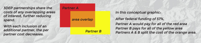
USGS’ vehicle for facilitating collaborative cost-sharing is the yearly Broad Agency Announcement (BAA). This is a competitive grant application process announced each August by the USGS as a call for proposals from state and local agencies as well as public and private NGO’s seeking federal matching funds to help finance large area LiDAR surveys. In addition to federal funding, 3DEP participants can realize greater cost savings through the formation of partnerships.
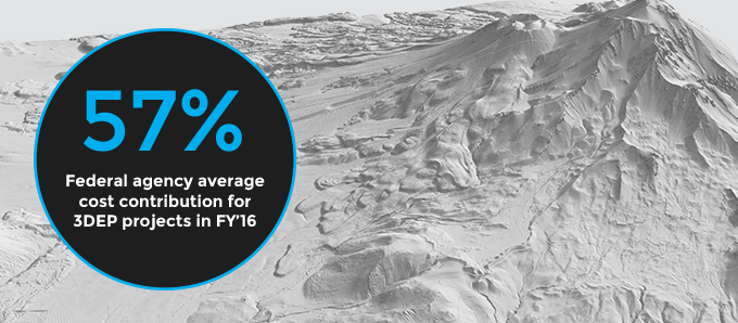
Understanding probable per unit cost for the area is essential to gauge scope that will be supported by partnership budget. In the last three years, USGS has selected 90 BAA applications, resulting in a combined value of all 3DEP funding sources of over $120 million dollars. In FY’16, federal agencies on average contributed 57% of 3DEP costs, providing a robust savings opportunity for 3DEP participants.
Building a successful application
In aiding a large number of successful 3DEP BAA submissions across the country we have learned that strong applications have compelling project justifications, strong cost models, and technical approach.
Building partnerships and cost share models that factor in technology specifications is a critical element of constructing a proposal. National organizations like Quantum Spatial that work with many different entities can be an invaluable resource in this regard.
Over the last three years, Quantum Spatial has collected over 170,000 square miles of LiDAR specifically for the 3DEP initiative as a USGS contractor. With our understanding of USGS v1.2 standards and specifications, experience with collection across a great diversity of landscapes, and use of the most advanced LiDAR technology, we provide valuable BAA application guidance to partnerships.
Get in touch with our team to optimize the value of LiDAR data.
Michael Shillenn: 610-724-7661 • mshillenn@quantumspatial.com