
Mark Knapp, D&I Solutions Engineer, NV5
We are living in the most data-rich period in the history of geospatial intelligence. Commercial constellations revisit the same spot several times a day. SAR sees through clouds and darkness. Hyperspectral sensors pick out materials the human eye can’t. Drones, aircraft, and maritime platforms stream data from the tactical edge. If speed to mission were only about collection, the problem would be solved.
It isn’t. Ask any analyst, commander or emergency manager where time is lost, and they rarely say, “we couldn’t get an image.” They say the data arrived in the wrong format. It sat in a system nobody else could reach. It needed hours of manual prep before anyone could analyze it. Or the AI model that worked well in a demo never made it into daily operations. The community has increasingly named this problem plainly: disconnected data, inconsistent formats, and the difficulty of putting AI into operation are what slow the mission down, not a shortage of pixels.
My view is simple. Speed to mission is a property of the whole pipeline, not of any single tool. Improving one stage does little if the stages on either side can’t keep up.
Speed serves the OODA loop
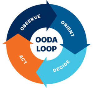
Military and commercial leaders already have a trusted decision model: Observe, Orient, Decide, Act. The OODA loop doesn’t need replacing; it needs a faster engine. The GEOINT pipeline is that engine. It turns observe into orient quickly enough that decide and act happen while they still matter.
Seen from sensor to decision, the pipeline has seven stages. Each one can either keep things moving or stall them.
1. Sensors: start with the right question
The fastest collection is the one you don’t have to repeat. Before anything is tasked, planners need to know which sensors can actually see the target, when they’ll be overhead, and under what conditions. Collection feasibility used to mean days of back-and-forth. It can now be modeled ahead of time, matching mission needs to sensor characteristics and upcoming overpasses. Tools like NV5’s DIAL point to where this is going: deciding what to collect, and when, before the clock starts.
2 . Edge: process where the data is born
Bandwidth is limited, and contested or disconnected environments are the norm, not the exception. Sending raw data home before anyone looks at it builds delay into the system. Running analytics at the edge (on aircraft, in vehicles, at forward locations) lets you send forward the answer instead of the raw data.
3. Processing: make preparation invisible
Calibration, orthorectification, pan-sharpening and format conversion are necessary but don’t set anyone apart. They should happen automatically, consistently, and at scale. Workflow orchestration platforms such as ENVI® turn proven analyst tradecraft into repeatable production pipelines. Then the hundredth run is as reliable as the first, and nobody has to rebuild a process at 2 a.m.
4. Data fusion: break down the silos
No single sensor tells the whole story. EO shows what something looks like, SAR shows what changed, hyperspectral shows what it’s made of, and vector, AIS, or open-source data shows how it’s connected. Fusion is where data turns into context. It only works when the data shares common formats and standards and can be found across systems. This stage gets the least attention, and in my experience it’s where the most time is lost.
5. AI and analytics: from demo to dependable
AI’s promise in GEOINT is real, but so is the gap between a promising model and a trusted operational capability. Agentic AI is starting to close that gap. These systems understand an analyst’s intent, plan the steps, run proven scientific analytics and record every decision so results can be audited and reproduced. NV5’s GeoAI solutions show the range this takes:
- ENVI Agent helps the analyst inside a familiar analytical tool.
- GeoIQ reasons across datasets to answer questions.
- GeoAgent orchestrates workflows across systems that others depend on.
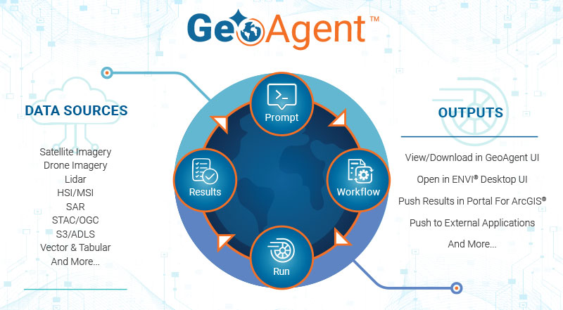
The key principle is that the analyst stays in the loop. Transparency builds trust, and trust is what moves AI out of the lab and into the mission.
6. Visualization: clarity over complexity
A brilliant analytic result that a decision-maker can’t take in at a glance doesn’t help. Visualization means getting results into the common operating picture and the GIS platforms teams already use, in a form people can act on.
7. Decision: the only output that matters
Every earlier stage exists to support this one. The real measure of a GEOINT pipeline isn’t terabytes processed or models deployed. It’s how much sooner a person can make a confident, well-informed decision.
Why owning the whole chain matters
Every handoff between organizations, systems, or formats adds time. Pipelines built from loosely connected point solutions accumulate those delays without anyone noticing. Organizations that can work across collection, processing, analytics, and delivery can remove those seams. NV5 has invested deliberately along that whole length, not just in analytics. Still, the broader lesson applies across the industry: design for the flow, not for the stage.
A reason for optimism
It’s easy to feel overwhelmed by the volume of geospatial data arriving every day. I see it differently. For the first time, the tools to keep up with that volume are within reach: feasibility modeling, edge computing, orchestrated processing, multimodal fusion, and trustworthy, explainable AI. The challenge has shifted from “can we do this?” to “will we connect it?”
That is a solvable problem, and a hopeful one. When the pipeline works as a whole, analysts spend less time preparing data and more time thinking. Decisionmakers get clarity sooner. Missions, whether defense, disaster response, maritime security, or infrastructure protection, move at the speed they require.
The sensors are ready. The analytics are ready. The next step is to build pipelines worthy of both.
If you would like to discuss a solution that works best for your organization, send me an email at GeospatialInfo@NV5.com.