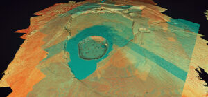
Volcanic GIS: Mapping and imaging the Kilauea eruption
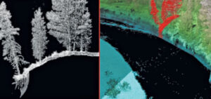
LiDAR data, collected by Quantum Spatial, is proving a useful tool in mapping the volcano and lava flows on the Big Island of Hawaii. Tracy Cozzens of
LiDAR data, collected by Quantum Spatial, is proving a useful tool in mapping the volcano and lava flows on the Big Island of Hawaii. Tracy Cozzens of
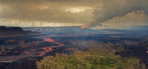
Hurricanes, flooding, landslides, wildfires and erupting volcanoes- rarely a week goes by without a headline about these types of natural disasters, which result in untimely
Quantum Spatial has conducted a LiDAR survey and data analysis of the volcanic activity in Hawaii. Tracy Cozzens, of Geospatial Solutions details how USGS Hawaiian
This week, five Quantum Spatial geospatial professionals — Russ Faux, senior vice president, Enterprise Growth Initiatives; Kurt Allen, Federal Programs Lead, Colin Cooper, technical domain
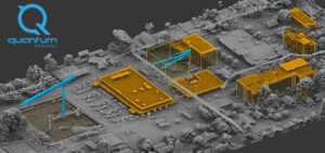
Colin Cooper and Russ Faux discuss the possibilities of topobathy LiDAR survey and evaluate the latest sensor technology and deployment methods in the most recent

Quantum Spatial, Inc.(QSI), the nation’s largest independent geospatial data firm, today announced that three of its LiDAR experts will be featured speakers at International LiDAR
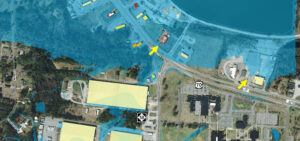
Michael Shillenn, of Quantum Spatial, details how North Carolina is managing flood risk through improved mapping and analysis of LiDAR data, made possible via the
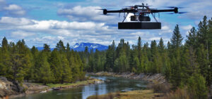
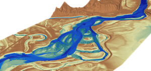
Teaming with experts from LiDAR manufacturer RIEGL, Quantum Spatial, Inc. was recently involved in an exciting new test of RIEGL’s newest sUAS technology innovation for hydrographic applications –
Here we are in Oakland for Cal GIS LocationCon ’17, running from May 22-24th! We can’t wait to learn more about some of the latest GIS
Sharita Towne, artist in residence at Newspace Center for Photography, worked with Quantum Spatial to visualize neighborhood changes using 3D LiDAR data. The final change