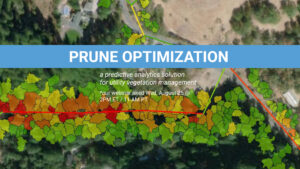
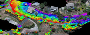
NV5 Geospatial Launches Prune Optimization
Prune Optimization – Wednesday, August 25th @ 2 PM ET. Access Recording NV5 Geospatial, powered by Quantum Spatial, North America’s largest geospatial data firm, today announced
Prune Optimization – Wednesday, August 25th @ 2 PM ET. Access Recording NV5 Geospatial, powered by Quantum Spatial, North America’s largest geospatial data firm, today announced

The NV5 Geospatial Anchorage office focuses on conducting environmentally responsible and sustainable projects across Alaska that help us adapt to a changing landscape and climate
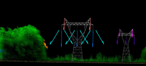
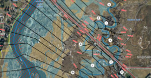
Electric utilities have been under intense scrutiny in recent years, plagued with questions about reliability because of expansive power outages and facing potential culpability for

Tracy Cozzens, senior editor of Geospatial Solutions, writes about the women of NV5 Geospatial’s eGIS team, and the diverse work they do to support science

Register Here NV5 Geospatial’s INSITE LIFECYCLE combines project tracking with data quality assurance and control. Providing instant access to geospatial data allows for a collaborative
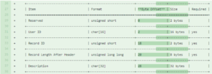
Evon Silvia, solutions architect with NV5 Geospatial, is chair of the ASPRS LAS Working Group. Dedicated to the development and standardization of lidar data, Evon
With the recent acquisition of Geodynamics LLC, NV5 Geospatial has built one of the most comprehensive suites of solutions for geospatial surveys of deep water and
Sven Cowan, Canada Program Manager for NV5 Geospatial, discusses the capabilities of INSITE Project Tracker a cloud-based data application for Go Geomatics Canada. The INSITE
Listen The UAV Podcast discusses how drones and other autonomous vehicles are deployed with lidar sensors to create 3D mapping data and downstream