Caught in a landslide? Know the realities
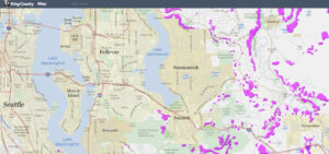
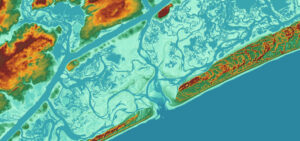
In response to the deadly Oso Landslide of 2014, government agencies have been working diligently to update landslide hazard analysis. Because LiDAR data can map
In response to the deadly Oso Landslide of 2014, government agencies have been working diligently to update landslide hazard analysis. Because LiDAR data can map

Sharita Towne, artist in residence at Newspace Center for Photography, worked with Quantum Spatial to visualize neighborhood changes using 3D LiDAR data. The final change

Many organizations, private and public, assume that the remote sensing data they need to fulfill their mission like emergency response management, natural resource planning, urban
Quantum Spatial is pleased to report that our attendance at this year’s International ISA Conference in Fort Worth, TX was a resounding success! From Sunday

Starting on August 25, Caitlin is hosting I Love Anchorage’s instagram feed for a week. Follow along to glimpse snapshots of her daily routine on and off
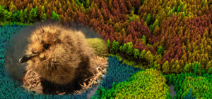
It’s so exciting to see Quantum Spatial’s LiDAR data come to fruition in helping wildlife biologists and forest managers better understand coastal old-growth canopy structure
In just a few days Quantum Spatial will land in Fort Worth, Texas for the International Society of Arboriculture Conference and Trade Show (ISA). We will be
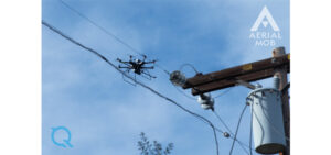
Aerial MOB, LLC, a leader in UAS (drone) aerial technology applications, has reached a strategic partnership agreement with Quantum Spatial Inc. (QSI), a leading supplier
The NOAA Sandy Supplemental Sandy Topobathy LiDAR and Imagery project was recognized has been recognized with the LCDR Peter Johnson Best Practices Award at the
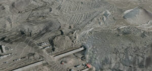
Quantum Spatial collected and analyzed LiDAR data for Utah’s Automated Geographic Reference Center. Government officials and researchers are using the LiDAR datasets in applications ranging