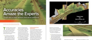
Accuracies Amaze the Experts
Lidar technology continues to advance, both in terms of sensor hardware and platform deployment. NV5 Geospatial and Oklahoma Department of Transportation performed a series of tests
Lidar technology continues to advance, both in terms of sensor hardware and platform deployment. NV5 Geospatial and Oklahoma Department of Transportation performed a series of tests
NV5 Geospatial, powered by Quantum Spatial, North America’s largest geospatial data firm, has dramatically expanded its Canadian operations in 2020, having been selected to provide lidar,
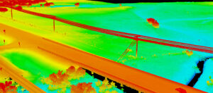
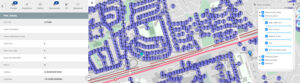
Keeping transportation projects on time and on budget can be a challenge for numerous reasons. But inaccurate mapping shouldn’t be one of them. NV5 Geospatial’s
HOLLYWOOD, FLA. (PRWEB) OCTOBER 21, 2020 Quantum Spatial, Inc., an NV5 company and North America’s largest geospatial data firm, recently completed the collection of topographic and

This week on RoboPsych podcast, hosts Carla and Tom welcome Dr. Scott Nowicki. Scott is a remote sensing expert and lead R&D scientist for Quantum
https://gogeomatics.ca/elexicon-energy-and-quantum-spatial-canada-pilot-comprehensive-mobile-mapping-project/

Ian Berdie, Quantum Spatial Vice President of Innovation and Development, sits down with GISCafe’s President, Sanjay Gangal, as they discuss how Quantum Spatial provides insights to clients,
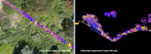
In the latest issue of Civil + Structural Engineer, Mike Stys, Vice President at NV5, discusses how the emergence of UAV systems (drones) are transforming

HOLLYWOOD, Fla., June 24, 2020 /PRNewswire-PRWeb/ — Quantum Spatial, Inc., an NV5 company and the nation’s largest geospatial data firm, today announced that Cherie Jarvis has been promoted to director of

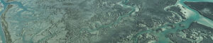
Julie Stricker, for Alaska Business Magazine reports how lidar and remote sensing data and analysis help oil and gas companies understand topography in order to make informed management decisions.