
Enhancing Situational Awareness with Remote Sensing Technologies
Modern Defense & Intelligence situational awareness hinges on the ability to turn the constant influx of information into timely, actionable understanding. But as volumes grow and threats accelerate,
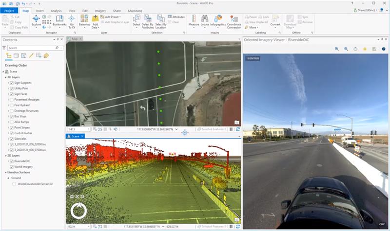
From Data Points to Defensible Decisions: Building AI-Ready Infrastructure Intelligence
Transportation agencies have collected large-scale infrastructure data for years. Yet many DOTs are still stuck in a familiar pattern: they invest heavily in collection, receive massive datasets,
From Public Data to Public Insight: Making Government GIS Work for Everyone
Local governments have been using Geographic Information Systems (GIS) in some capacity for decades now, making it easier to collect, manage, and share large sets
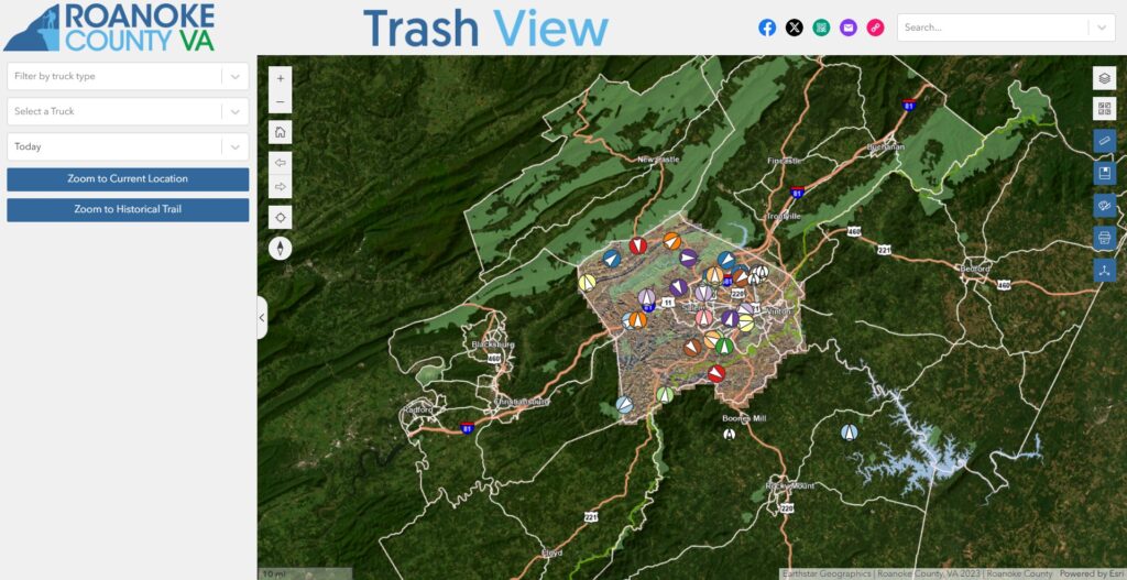
Smarter Waste Management: How Roanoke County is Transforming Trash Collection with NV5 & Esri ArcGIS Experience Builder
Expert NV5 Speakers to Present on Bathymetric Lidar, Airborne Mapping, Remote Sensing Innovation, Photogrammetry, ASPRS Standards, and the Future of Geospatial Intelligence Roanoke County, VA,

NV5 to Showcase at Geo Week 2026 Next‑Generation GeoAI and Mission‑Critical Geospatial Solutions
Expert NV5 Speakers to Present on Bathymetric Lidar, Airborne Mapping, Remote Sensing Innovation, Photogrammetry, ASPRS Standards, and the Future of Geospatial Intelligence NV5, the world’s

NV5 Launches GeoAgent, Ushering in the Era of Autonomous Geospatial Intelligence
NV5 today announced the launch of GeoAgent™, an agentic AI platform that automatically discovers and analyzes data and produces geospatial intelligence using natural language interaction.
Why You Should Own Your Geospatial Data
In the digital era of transportation infrastructure, data is as foundational as concrete and steel. Yet, a critical issue often lurks in the fine print:
How GIS Can Be Used in the Transportation Planning Phase
In order to pull off transportation projects that improve safety and efficiency for travelers, the planning phase is critical. There are massive amounts of data
Tualatin Valley Water District Strengthens System Resilience with ArcGIS Utility Network
Tualatin Valley Water District (TVWD) is taking a data-driven approach to capital planning, using ArcGIS Utility Network and custom tracing tools developed with NV5 to