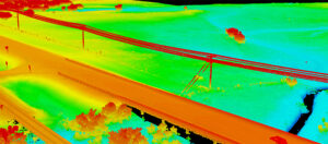
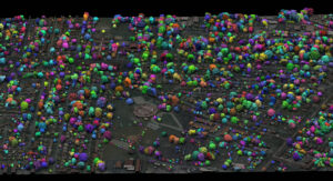
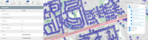
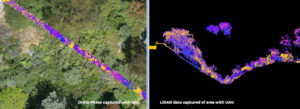
Comparing Lidar Sensor and Platform Performance for Transportation
Keeping transportation projects on time and on budget can be a challenge for numerous reasons. But inaccurate mapping shouldn’t be one of them. NV5 Geospatial’s
Keeping transportation projects on time and on budget can be a challenge for numerous reasons. But inaccurate mapping shouldn’t be one of them. NV5 Geospatial’s

HOLLYWOOD, FLA. (PRWEB) OCTOBER 21, 2020 Quantum Spatial, Inc., an NV5 company and North America’s largest geospatial data firm, recently completed the collection of topographic and

This week on RoboPsych podcast, hosts Carla and Tom welcome Dr. Scott Nowicki. Scott is a remote sensing expert and lead R&D scientist for Quantum

HOLLYWOOD, Fla., Oct. 12, 2020 (GLOBE NEWSWIRE) — NV5 Global, Inc. (the “Company” or “NV5”) (Nasdaq: NVEE), a provider of compliance, technology, and engineering consulting solutions,
In recent years, advances in high-density lidar and hyperspectral imagery have offered new tools to states and municipalities for vegetation management. Quantum Spatial’s Andrew Brenner
HOLLYWOOD, Fla., Sept. 30, 2020 (GLOBE NEWSWIRE) — NV5 Global, Inc. (the “Company” or “NV5”) (Nasdaq: NVEE), a provider of compliance, technology, and engineering consulting solutions, announced today that its
https://gogeomatics.ca/elexicon-energy-and-quantum-spatial-canada-pilot-comprehensive-mobile-mapping-project/

Quantum Spatial, Inc., an NV5 company and the nation’s largest geospatial data firm, today announced that it is the first full-service geospatial company to achieve International

Ian Berdie, Quantum Spatial Vice President of Innovation and Development, sits down with GISCafe’s President, Sanjay Gangal, as they discuss how Quantum Spatial provides insights to clients,
In the latest issue of Civil + Structural Engineer, Mike Stys, Vice President at NV5, discusses how the emergence of UAV systems (drones) are transforming