A New Way to Present Spatial Data

For GIS professionals, overlaying multiple geospatial data layers on a map for analysis and decision making is all part of a day’s work, but for most people geospatial analysis begins and ends with typing a destination into a mapping app and following the directions. Conveying complex geospatial information in a meaningful way to non-GIS professionals is a challenge that Quantum Spatial is solving for the Bureau of Ocean Energy Management (BOEM) and the National Oceanic and Atmospheric Administration (NOAA) through development of the Ocean Reporting Tool (ORT).

The ORT was highlighted during a session presentation by Christine Taylor (BOEM) and later demonstrated by David Stein (NOAA) and Jeff Skahill (Quantum Spatial), at the recent Coastal GeoTools conference in Charleston, South Carolina. Both presentations received positive feedback and many questions were asked about the public roll-out of the application. The product is currently being deployed on NOAA’s infrastructure with the expectation that it will be available to the public later this year. The current release is focused on the offshore East Coast waters from Virginia to Florida, but future enhancements will extend the geography to include all coastal areas.

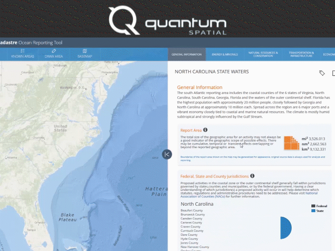
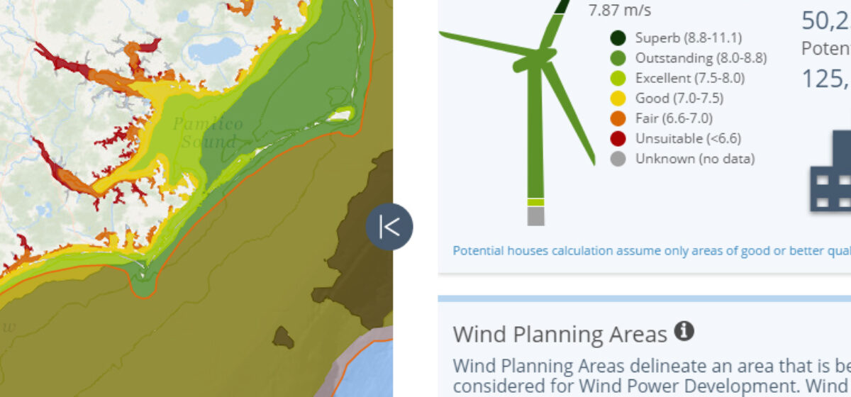
ORT will be part of MarineCadastre.gov which is a joint initiative between BOEM and NOAA to provide authoritative data to the offshore energy and marine planning community. The Ocean Reporting Tool, currently under development, is a complementary component to the MarineCadastre’s existing tools and offers an easy to consume, but content rich, visualization of ocean-based data for public users who may not have geospatial expertise, such as ocean planners, policy analysts, and the press.

Quantum Spatial has been working with BOEM and NOAA to design and develop all components of this new application. The project began with a vision from BOEM and NOAA that needed to be translated to a working solution. To move forward on bringing the most value to our clients, Quantum Spatial employed their customized agile methodology to iterate through requirements gathering sessions, wireframe reviews, data prototyping and development, then front-end and back-end development to build a tool that fulfills the initial vision.

Quantum Spatial is utilizing their experience in data development, UI/UX design, application development, and system integration. The tool is built in JavaScript using the AngularJS framework and Leaflet library on top of ArcGIS for Server services. The geospatial content is provisioned through a complex geoprocessing service that renders data for over 40 different infographics.

Quantum Spatial’s Enterprise GIS team is providing its expertise to many clients in the natural resource management community, and is ready to help you solve your challenging problems!

Fill out the form below to download the handbook.

Form #1 - Redirection to PDF

Form #2 - Sends email containing the link to the PDF

"*" indicates required fields

This field is for validation purposes and should be left unchanged.

eNewsletter - NV5 Real Estate Transaction Services

Contact NV5 Real Estate Transaction Services

Download NV5 2022 Compliance Calendar

Please fill out the form below. After successful form submission, you will be redirected to the requested file. Thank you.

  • We are an equal opportunity employer. All applicants will be considered for employment without attention to race, color, religion, sex, sexual orientation, gender identity, national origin, veteran or disability status. We ensure nondiscrimination in all programs and activities in accordance with Title VI of the United States Civil Rights Act of 1964. If you need more information or special assistance for persons with disabilities or limited English proficiency, contact MaryJo OBrien at (954) 495-2112. Persons with hearing-and speech-impairments can contact the NV5 by using the Virginia Relay Service, a toll-free telecommunication device for the deaf (TDD). Call 711 for TTY/TDD.

Hyperspectral Imaging - Technically Speaking

Our internal innovation and development team constantly analyzes new technology and develops solutions to meet our client’s challenges. Our Technically Speaking series is one way we share our technical findings with the professional community. 

Please tell us a little about yourself by filling out the form below, and we’ll share the document with you, thanks!

Accuracy Part 1- Technically Speaking

Our internal innovation and development team constantly analyzes new technology and develops solutions to meet our client’s challenges. Our Technically Speaking series is one way we share our technical findings with the professional community. 

Please tell us a little about yourself by filling out the form below, and we’ll share the document with you, thanks!

Prune Optimization Webinar Recording

NV5 Geospatial releases a new predictive modeling platform for vegetation management that uses existing lidar and historical data to identify the relative level of asset risk from trees by quantifying the potential for causing asset damage. 

Please tell us a little about yourself by filling out the form below, and we’ll share the document with you, thanks!

Topobathy Lidar - Technically Speaking

Our internal innovation and development team constantly analyzes new technology and develops solutions to meet our client’s challenges. Our Technically Speaking series is one way we share our technical findings with the professional community. 

Please tell us a little about yourself by filling out the form below, and we’ll share the document with you, thanks!

Contact Geospatial

Contact Geospatial