Beyond transmission: How remote sensing speeds inspection and management of distribution networks

Keeping the proverbial lights on is no small task. Electric utilities go to great lengths to ensure safe, reliable energy.  Maintaining the distribution network in the midst of increasing demand for both energy output as well as infrastructure demand is a vast undertaking. Eric Merten, Director of Professional Services- Private Markets, explains how innovative solutions at Quantum Spatial are improving speed, accuracy, and value in comparison to traditional boots-on-the-ground methods of assessment and inspection.  Read the full article at Utility Dive.  Excerpt below: 

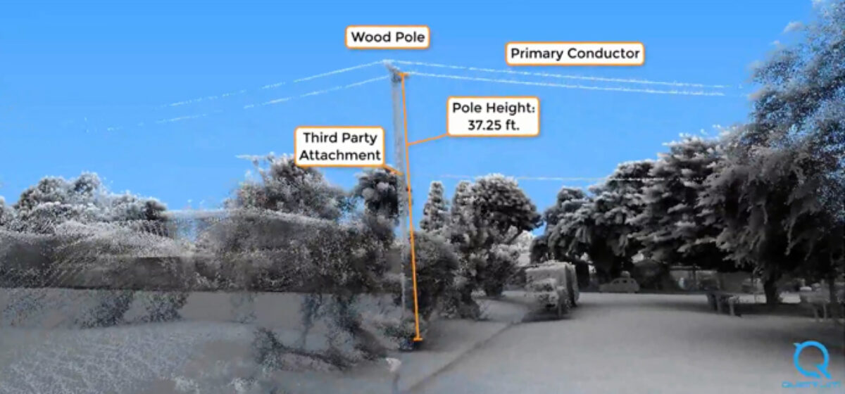
This data can be replicated identically pole after pole, and year after year, to gain an understanding of the assets’ condition, surrounding environment and use over time.

This detailed information can reduce the amount of time it takes for inspections. For example, in some cases, utilities can perform a full clearance analysis on 10,000 poles in just two months — four to six times faster than it can achieve with boots on the ground.

It also takes human error out of the measurement process, with LiDAR providing a “digital twin” with measurements that are systematic and repeatable.

Fill out the form below to download the handbook.

Form #1 - Redirection to PDF

Form #2 - Sends email containing the link to the PDF

"*" indicates required fields

This field is for validation purposes and should be left unchanged.

eNewsletter - NV5 Real Estate Transaction Services

Contact NV5 Real Estate Transaction Services

Download NV5 2022 Compliance Calendar

Please fill out the form below. After successful form submission, you will be redirected to the requested file. Thank you.

  • We are an equal opportunity employer. All applicants will be considered for employment without attention to race, color, religion, sex, sexual orientation, gender identity, national origin, veteran or disability status. We ensure nondiscrimination in all programs and activities in accordance with Title VI of the United States Civil Rights Act of 1964. If you need more information or special assistance for persons with disabilities or limited English proficiency, contact MaryJo OBrien at (954) 495-2112. Persons with hearing-and speech-impairments can contact the NV5 by using the Virginia Relay Service, a toll-free telecommunication device for the deaf (TDD). Call 711 for TTY/TDD.

Hyperspectral Imaging - Technically Speaking

Our internal innovation and development team constantly analyzes new technology and develops solutions to meet our client’s challenges. Our Technically Speaking series is one way we share our technical findings with the professional community. 

Please tell us a little about yourself by filling out the form below, and we’ll share the document with you, thanks!

Accuracy Part 1- Technically Speaking

Our internal innovation and development team constantly analyzes new technology and develops solutions to meet our client’s challenges. Our Technically Speaking series is one way we share our technical findings with the professional community. 

Please tell us a little about yourself by filling out the form below, and we’ll share the document with you, thanks!

Prune Optimization Webinar Recording

NV5 Geospatial releases a new predictive modeling platform for vegetation management that uses existing lidar and historical data to identify the relative level of asset risk from trees by quantifying the potential for causing asset damage. 

Please tell us a little about yourself by filling out the form below, and we’ll share the document with you, thanks!

Topobathy Lidar - Technically Speaking

Our internal innovation and development team constantly analyzes new technology and develops solutions to meet our client’s challenges. Our Technically Speaking series is one way we share our technical findings with the professional community. 

Please tell us a little about yourself by filling out the form below, and we’ll share the document with you, thanks!

Contact Geospatial

Contact Geospatial