Quantum Spatial, Inc., North America’s largest independent geospatial analytics firm, will deliver two presentations focusing on how utility companies use remote sensing and lidar during CEATI’s 2019 Vegetation Management Conference, December 3-4 in San Antonio, Texas. During the conference, Quantum Spatial will discuss its contributions to projects for several utility companies, including DTE Energy.
“No matter where they’re located, it is critical for utility companies to mitigate hazards related to vegetation around critical infrastructure, so they can ensure the health, reliability, stability and safety of their transmission and distribution networks,” said Eric Merten,vice president and general manager, Commercial Markets at Quantum Spatial. “At CEATI, we look forward to sharing how we are helping utilities identify vegetation threats, move to condition based maintenance and negotiate trimming contracts through the use of remote sensing and lidar.”
Quantum Spatial executives and customer experts will be speakers in the following two CEATI sessions:
- – Condition-Based Maintenance Using Remote Sensing, December 3, 2019 3:30 pm Central.
Jacob Hall, vice president of Energy Sales for Utilities at Quantum Spatial, will discuss a novel application of remote sensing and machine learning to effectively identify risks from the Emerald Ash Borer (EAB) within the transmission right-of-way. Since the early 2000’s an infestation of the EAB has caused widespread mortality in the Midwestern population of Ash trees. These dead and dying trees pose a significant potential threat to the electrical grid.
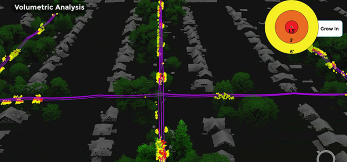
- – Using Lidar to Negotiate Distribution Vegetation Management Contracts, December 3, 2109, 11:00 am Central.
Craig Jackson, manager of Forestry Planning, Auditing, and Herbicides at DTE Energy, and Mike Fuller, director of Energy Solutions for Quantum Spatial, will discuss the utility’s experience using high-density lidar to aid their distribution vegetation management program within the Detroit metro area. This presentation addresses lidar’s applicability and suitability for distribution vegetation management programs. Jackson and Fuller will cover DTE’s anticipated project benefits by highlighting the project scope, execution, and DTE’s ability to leverage the lidar results to negotiate improved rates with DTE’s trimming contractors.
Quantum Spatial also will exhibit in Booth 13, where the company’s geospatial experts will be available to discuss these projects, the technologies used and analytic capabilities.
To meet with Quantum Spatial during CEATI, contact Mike Fuller, Director of Energy Solutions, at mfuller@quantumspatial.com (at) quantumspatial (dot) com.
About Quantum Spatial, Inc.
Quantum Spatial, Inc., the nation’s largest independent geospatial data firm, provides geographic insights to the largest government and corporate organizations that need geospatial intelligence to mitigate risk, plan for growth, better manage resources and advance scientific understanding. A pioneer in advanced mapping technology, QSI’s end-to-end solutions and services deliver the industry’s highest data quality and accuracy, while leveraging the widest array of technologies for analyzing all types of terrains. Customers use the company’s acquisition, processing, analytics and visualization solutions in a range of technical and scientific disciplines – from geology and biology, to hydrology, forestry and civil engineering. Utilities, oil and gas producers, engineering and construction firms, as well as the military and major government agencies, are QSI customers. QSI has multiple offices around the country.